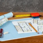
Embarking on a home improvement project is an exhilarating journey, whether you are envisioning a sparkling new swimming pool, a spacious garage addition, or a wrap-around deck for summer entertaining. However, before you can break ground or lay the first brick, you must navigate the often-intimidating hurdle of the municipal building department. This is where the residential site plan becomes your most valuable asset. It is not merely a drawing; it is the fundamental language used to communicate your vision to city officials.
Many homeowners mistakenly believe that a simple sketch or an interior floor plan will suffice for their permit application, only to face frustrating rejections and costly delays. A comprehensive site plan bridges the gap between your dream and the reality of local zoning laws. By clearly defining boundaries, setbacks, and structural footprints, you provide the city with the assurance that your project is safe, legal, and compliant. Understanding this document is the first step toward a seamless construction process.
1. The Anatomy of a Permit-Ready Site Plan
A residential site plan is far more than a simple outline of your house; it is a technical document that must contain specific data points to pass a zoning review. When a city planner reviews your application, they are not looking at the aesthetics of your renovation; they are looking for mathematical proof that the structure fits the land legality. The plan must be drawn to an engineer’s scale (such as 1″=20′) so that officials can measure distances directly on the paper to verify your claims.
- North Arrow and Scale: Standard orientation and measurement ratios are non-negotiable for clarity.
- Property Lines and Dimensions: Accurate lengths of all lot lines derived from county records or deed descriptions.
- Proposed vs. Existing Structures: Visual distinction (often using different line weights or hatching) between what is currently there and what you intend to build.
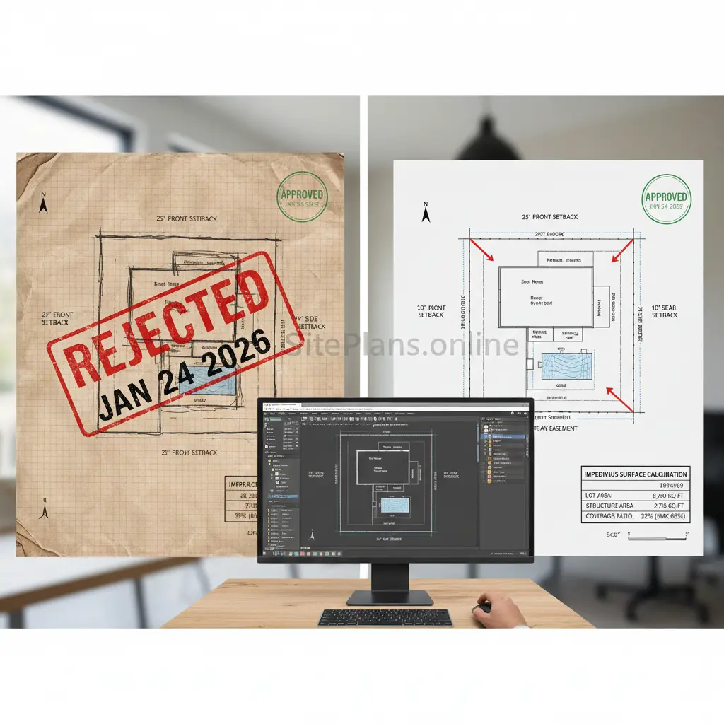
These elements create a “trust framework” for the reviewer. If a plan lacks a scale bar or a North arrow, the reviewer cannot verify the setbacks, and they are legally required to reject the application immediately, regardless of how simple the project is.
2. Zoning Setbacks and Easements
The most critical function of a residential site plan is to demonstrate compliance with “invisible” restrictions like setbacks and easements. Setbacks are the mandatory distances you must keep between your structure and the property lines, while easements are designated areas of your land that must remain accessible for utilities or municipal services. Your site plan must explicitly label these distances to prove your new garage or fence isn’t encroaching on a neighbor’s land or sitting on top of a sewer line.
- Front, Rear, and Side Setbacks: Clearly annotated measurements showing the exact distance from the new structure to the lot lines.
- Utility Easements: Dashed lines indicating areas where building is prohibited due to underground gas, water, or electric lines.
- Right-of-Way: Demarcation of public land, such as sidewalks or street verges, that borders your property.
Failure to identify an easement is one of the most expensive mistakes a homeowner can make. If you accidentally build a shed over a utility easement because it wasn’t on your site plan, the city has the legal right to force you to tear the structure down at your own expense.
3. Impervious Surface Coverage Calculations
Modern building departments are increasingly concerned with water drainage and environmental impact, which is why your site plan must calculate “impervious surface coverage.” This refers to the percentage of your lot that is covered by materials that water cannot penetrate, such as concrete, asphalt, and roofing. Municipalities have strict caps on this percentage to prevent stormwater runoff from flooding neighboring properties or overwhelming city sewers.
- Lot Area Calculation: The total square footage of your property boundaries.
- Structure Area Summation: A breakdown of the square footage of the house, driveway, patios, and sheds.
- Coverage Ratio: The final percentage (e.g., “Lot Coverage: 32%”) compared against the maximum allowed by your specific zoning district.
If your zoning district allows for 40% coverage and your plan shows you are at 42%, your permit will be denied. A professional site plan calculates these numbers for you, allowing you to adjust the size of your patio or driveway before you submit, ensuring you stay within the legal limits.
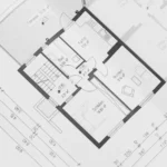
4. Site Plans vs. Floor Plans vs. Land Surve
There is significant confusion among homeowners regarding the difference between these three documents, yet they serve entirely different purposes in the eyes of the permit office. A floor plan shows the interior layout (walls, windows, doors), while a site plan shows the exterior relationship to the land. A land survey is a certified legal document signed by a licensed surveyor, whereas a site plan is a drafted representation used for planning and permits.
- Floor Plan: Required for electrical, plumbing, and structural changes inside the home.
- Land Survey: Required for legal boundary disputes or closing on a house; costs thousands of dollars.
- Site Plan: Required for zoning approval for fences, pools, and additions; costs a fraction of a survey.
For 90% of residential projects, such as building a deck or a fence, cities do not require an expensive new land survey. They require a current site plan that can be drafted using existing property data, saving you significant money that can be better spent on construction materials.
5. Common Reasons for Permit Rejection
Understanding why permits get rejected is the key to ensuring yours gets approved, and the vast majority of rejections stem from poor-quality site plans. Permit offices are bureaucratic entities that require standardized formatting; they do not have the time or patience to decipher ambiguous sketches. When a plan is unclear, the default answer is “no” because the liability of approving a non-compliant structure is too high for the city to accept.
- Missing Topographical Data: Failing to show steep slopes or retaining walls on hilly terrain.
- Inconsistent Scales: Using a ruler scale that doesn’t match the printed paper size (e.g., printing a 24×36 plan on 8.5×11 paper).
- Lack of Vicinity Map: Forgetting to include a small inset map showing where the lot is located within the neighborhood context.
By using a professional drafting service, you eliminate these variables. Professionals use CAD software that automatically enforces consistency in scale and ensuring that all standard “checklist” items—like the vicinity map and project data table—are present and correct.
6. How to Obtain a Site Plan Quickly
In the past, getting a site plan meant finding a local drafter, waiting for them to visit your property, and paying a premium for their travel time. Today, technology has revolutionized this process through satellite imagery, GIS (Geographic Information Systems) data, and county parcel maps. You can now order a site plan online without anyone ever stepping foot on your lawn, drastically reducing both the cost and the turnaround time.
- Submit Property Details: Provide your address and a description of the project (e.g., “adding a 12×12 shed in the back left corner”).
- Remote Drafting: Experts pull public records and satellite data to trace your lot lines and existing structures.
- Review and Submit: Receive a PDF or DWG file, print it to the correct scale, and attach it to your permit application.
This shift to remote drafting has democratized the permit process. What used to take two weeks and cost $800 can now be accomplished in 24 hours for under $150, removing the biggest administrative bottleneck for homeowners and contractors alike.
Conclusion: The Path to Permit Approval Starts Here
Navigating the complexities of city zoning and building permits can feel overwhelming, but it doesn’t have to be a roadblock to your dream project. The residential site plan is more than just a regulatory hurdle; it is the foundation of a successful build. By ensuring your plan is accurate, scaled, and compliant with local codes, you are protecting yourself from legal liabilities and ensuring a smooth approval process.
Don’t let a rejected application stall your timeline or inflate your budget. Whether you are installing a simple privacy fence or constructing a major home addition, starting with a professional-grade site plan is the smartest investment you can make. It transforms your vision from a concept into a verified, permit-ready reality.
Ready to get your project approved? Skip the stress of hand-drawing and the high cost of land surveyors. Get your professional residential site plan today and receive a permit-ready draft in as little as 24 hours.
Frequently Asked Questions (FAQs)
1. Can I draw my own residential site plan?
Technically, some municipalities allow homeowners to hand-draw plans for very minor projects. However, if your drawing lacks an engineer’s scale, accurate dimensions, or legibility, it will be rejected. Using a professional CAD service guarantees compliance and saves time.
2. Is a site plan the same as a survey?
No. A survey is a legal document signed by a licensed surveyor that establishes property lines with absolute legal certainty. A site plan is a drafting document based on those records, used specifically for demonstrating proposed improvements to the building department.
3. What file format does the building department need?
Most building departments today accept digital submissions in PDF format. If you are printing the plan, it must be on the correct paper size (usually 11×17 or 24×36) to maintain the correct scale.
4. How do I know where my setbacks are?
Setbacks are determined by your property’s zoning classification (e.g., R-1, R-2). You can find this information on your city’s GIS map or by calling the local zoning office. A professional site plan drafter can often locate this information for you.
5. Does a site plan show topography?
A basic site plan usually does not show topography. However, if you are building on a steep slope or in a flood zone, the city may require a site plan with topographical contour lines. This is typically an “Advanced” or “Elite” feature in drafting packages.
6. How long is a site plan valid for?
A site plan represents the property at a specific moment in time. If you add a patio or a shed, the old site plan is no longer accurate. You generally need a fresh, updated site plan for every new permit application you submit.