Imagine this: You are finally ready to build that dream deck or install a new privacy fence. You head to your local building department to pick up a permit application, and there, listed under the requirements, is a request for a “plot plan” or “site plan.” You call a local land surveyor, assuming it’s a quick formality, only to be quoted $2,000 and a three-week wait time. This is the “sticker shock” moment that stalls countless home projects.
The good news is that for the vast majority of residential improvements, you do not need to spend thousands on a certified survey. Most homeowners are unaware that there is a faster, more affordable alternative that satisfies city requirements just as effectively. A residential site plan is a professional drafting solution designed specifically for permit applications. By understanding the critical differences between these two documents, you can save your budget for the actual construction rather than administrative paperwork.
1. Defining the Contenders: Drafting vs. Surveying
To make the right choice, you must understand what you are actually buying. A land survey is a legal service involving fieldwork, where a licensed professional physically locates the iron pins at the corners of your property. A site plan is a drafting service that utilizes existing public records, satellite imagery, and GIS data to create a scaled representation of your lot.
- The Land Survey: Legally certifies exactly where your land begins and ends; carries liability insurance for boundary disputes.
- The Site Plan: Visually demonstrates the relationship between your lot lines and your proposed project; focuses on zoning compliance.
- The Overlap: Both documents show property lines and structures, but they serve different masters (the court of law vs. the planning department).
While a surveyor tells you exactly where the earth is, a drafter tells the city approximately where your new garage fits in relation to that earth. For 90% of routine permits, the city planner accepts the drafted version because they are checking for setbacks, not fighting a legal boundary war.
2. The Cost Breakdown: Where Does the Money Go?
The cost difference between these two services is massive, primarily due to the labor involved. A survey requires a crew to drive to your house, use expensive equipment, and spend hours measuring. A site plan for permit is created digitally by expert CAD drafters, drastically reducing the overhead.
- Surveyor Costs ($1,500+): Includes travel time, equipment usage, research at the county clerk’s office, and the surveyor’s professional seal.
- Site Plan Costs ($90 – $200): Includes access to digital databases, CAD drafting time, and file formatting.
- Hidden Costs: Surveyors often charge extra for “rush” orders, whereas digital site plans can often be delivered in under 24 hours as a standard service.
If your project budget is $5,000 for a new shed, spending $2,000 on a survey eats up 40% of your funds. Opting for a $150 site plan keeps your budget intact while still satisfying the permit office’s need for a scaled drawing.
3. Scenarios: Which Document Do You Actually Need?
This is the most critical section for homeowners. You don’t want to order a site plan if you actually need a survey, but you definitely don’t want to pay for a survey if a site plan would suffice. The distinction usually comes down to “New Construction” vs. “Minor Improvement” vs. “Legal Dispute.”
- Scenario A: Boundary Dispute (Need Survey): If your neighbor claims your fence is on their land, a drafted site plan won’t help. You need a surveyor to place physical markers.
- Scenario B: New Home Build (Need Survey): If you are building a brand new house on a vacant lot, the bank and city will almost always require a certified survey foundation location.
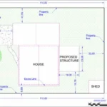
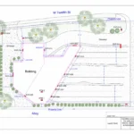
- Scenario C: Home Additions & Improvements (Need Site Plan): For decks, pools, sheds, fences, and driveways, a residential site plan is the industry standard.
The general rule of thumb is: If the bank or a lawyer is involved, get a survey. If only the city permit office is involved, a site plan is usually all you need.
4. The Non-Certified Myth
A common fear homeowners have is that the city will reject a plan because it isn’t “certified” by a surveyor. This is largely a myth for standard residential projects. Most building departments distinguish between a “boundary survey” (which needs a seal) and a “plot plan” (which essentially needs to be accurate and to scale).
- Municipal Requirements: Review your city’s permit checklist. If it asks for a “to-scale drawing” or “plot plan,” you do not need a surveyor’s seal.
- Drafting Accuracy: Professional drafters use the same county GIS data that surveyors use as a starting point.
- Disclaimer Acceptance: Site plans come with a disclaimer stating they are for “planning and permit purposes only,” which is exactly what the zoning officer is looking for.
City planners are pragmatic. They want to see that you aren’t building your pool five feet from the property line when the code says ten. A clear, professional CAD drawing demonstrates this perfectly, rendering the expensive surveyor’s seal unnecessary for the task at hand.
5. How to Convert Old Data into a Fresh Plan
Often, homeowners already have an old, faded survey in their closing papers from when they bought the house 15 years ago. While you can’t submit that old paper (because it doesn’t show your new project), you don’t need to start from scratch. You can use that old document as a “base” for a modern site plan.
- Upload the Old Survey: Provide the drafter with a scan or photo of your old survey.
- Add New Features: Tell the drafter, “I want to add a 20×20 garage here,” and they will digitally draw it onto the map.
- Modernize the Format: The final result is a crisp, digital file that looks brand new and includes all the necessary calculations for your current permit.
This hybrid approach is the most efficient way to get approved. It combines the accuracy of the original survey with the flexibility of modern drafting, giving the permit office exactly what they need without the wait.
Conclusion
When you are staring down a long list of permit requirements, the instinct is often to over-comply to avoid rejection. But paying for a land survey when you only need a site plan is like chartering a private jet to go grocery shopping—it gets the job done, but at an unnecessary cost.
For the vast majority of residential projects, a professionally drafted site plan is the perfect tool. It provides the scale, accuracy, and detail the city needs without the exorbitant fees and long wait times of a survey.
Ready to start your project without breaking the bank? Save $2,000 and weeks of waiting. Order your residential site plan today and get a permit-ready drawing delivered to your inbox in 24 hours.
Frequently Asked Questions (FAQs)
1. Will my city accept a site plan that isn’t signed by a surveyor?
Yes, for most residential improvements like fences, decks, and sheds, cities accept non-certified site plans. Always check your specific municipality’s “submittal requirements” list to be sure.
2. Can I use a satellite map from Google Earth?
No. Google Earth screenshots are not to scale and are often distorted. Permit offices will reject them. A professional site plan uses satellite data but corrects it to be a flat, scaled engineering drawing.
3. What if I don’t know my property dimensions?
Professional drafting services can usually retrieve this information for you using parcel maps and county GIS records, so you don’t need to go out and measure the lot yourself.
4. Does a site plan show my neighbor’s house? It typically shows the footprint of your structures and the property lines. However, if your project is very close to the boundary, a “vicinity map” (often included in advanced site plan packages) can show context.
5. How accurate are these site plans?
They are highly accurate for planning purposes, often within inches relative to the GIS data provided by the county. However, they are not a legal definition of the boundary line.
6. Can a site plan help me if I have a drainage issue?
Yes. You can order a site plan that includes topographical lines (elevation) to show how the land slopes. This is essential for proving to the city that your new driveway won’t cause flooding.