Navigating the building permit process in 2026 has become increasingly digital, data driven, and regulated. As local municipalities across the United States adopt stricter zoning codes, climate resiliency standards, and advanced GIS integration, the humble site plan has evolved from a simple sketch into a sophisticated technical document. Whether you are adding a minor deck, installing a luxury pool, or building a custom new home, understanding the current expectations of your local building department is the first step toward a successful project approval.
In 2026, the primary change for homeowners and contractors is the move toward Smart City integration. Most building departments now require high resolution PDF submissions that are compatible with their internal Geographic Information Systems (GIS). This means hand drawn sketches are almost universally rejected in favor of precise, CAD generated documents. When you look for reliable drafting services, you aren’t just paying for a drawing; you are paying for technical accuracy that matches the city’s digital parcel maps.
The Shift Toward Digital Submission Standards
The accuracy of your boundary lines and setbacks is now verified against satellite data and existing municipal records before a human reviewer even looks at your application. If there is a discrepancy between your submitted plan and the city’s digital records, the automated portal may flag your application for rejection before it even reaches a desk. This Gatekeeper software is becoming standard in major metropolitan areas from Austin to Atlanta, making professional precision a necessity rather than an option.
Essential Components of a 2026 Site Plan
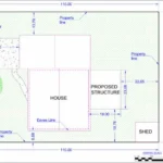
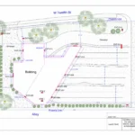
A standard site plan must provide a comprehensive bird’s eye view of the property. However, the level of detail required has increased significantly over the last few years. In years past, showing the house and the proposed addition was often enough. Today, you must account for every square inch of the property to ensure compliance with a myriad of local ordinances.
- Property Boundaries and Setbacks: Clear indications of property lines and the exact distance from the proposed structure to those lines.
- Existing vs. Proposed Structures: Differentiating between what is currently on the land and what you intend to build using distinct line weights or shading.
- Topography and Grade: In many regions, showing the slope of the land via contour lines is now mandatory to predict water runoff and drainage patterns.
- Utility Locations: Including water lines, sewer or septic locations, and overhead power lines to avoid strike zones during construction.
- Easements and Rights of Way: Identifying areas where utility companies or the city have access rights, which can strictly limit where you can build.
- North Arrow and Scale: A fundamental requirement that ensures the reviewer can orient the property and measure distances accurately.
If you are confused about how these elements look on paper, reviewing professional residential site plan examples can help clarify the level of detail your local reviewer expects to see.
Why Lot Coverage Calculations Matter More Than Ever
Building departments are under increasing pressure to manage urban heat islands and stormwater flooding. As a result, 2026 regulations focus heavily on lot coverage ratios—the percentage of your land covered by buildings, driveways, and other non porous materials. If your project exceeds the allowed lot coverage, your permit will be denied immediately or require a costly variance hearing.
A modern site plan must include a detailed Data Table or Zoning Summary breaking down the square footage of the existing house, the proposed addition, the driveway, and even small sheds. This data allows the plan checker to verify that your property still has enough permeable space to absorb rainwater. For those dealing with complex projects like multi unit developments, subdivision site plans often require even more rigorous calculations regarding shared drainage and infrastructure impacts.
The Rise of the Total Site Impact Philosophy
In 2026, reviewers are no longer looking at your project in isolation. They are looking at the Total Site Impact. This means that even if you are just building a 200 square foot shed, the building department wants to see how that shed affects the overall drainage of the neighborhood.
- Drainage Arrows: You must now show the intended direction of water flow across your property.
- Silt Fencing: Temporary erosion control measures must be noted on the plan if the area of disturbance exceeds a certain threshold.
- Impervious Surface Credits: Some cities now offer credits if you use permeable pavers instead of standard concrete; these must be clearly labeled to get the credit.
Addressing Environmental and Zoning Overlays
Many U.S. properties fall under overlays—special sets of rules that sit on top of standard zoning. These might include historic districts, wildland urban interface (fire zones), or floodplains. In 2026, if your property is in a flood prone area, your site plan must likely show Base Flood Elevation (BFE) and how your project complies with FEMA requirements.
Furthermore, tree preservation is a major focus this year. Many cities now require a Tree Protection Plan as part of the site plan, showing the location of all protected trees and the drip line where construction equipment is not allowed to travel. This prevents soil compaction and ensures the long term health of the city’s canopy. If you fail to show a 12 inch diameter oak tree on your plan, you could face massive fines during the inspection phase.
Coordination with Other Architectural Drawings

While the site plan is the map of your project, it must coordinate perfectly with your other documents. In 2026, plan checkers often perform a digital cross check between your site plan and your elevation plan drawing. If the site plan shows a 10 foot setback but the elevation shows a roof overhang that extends into that setback, the plans will be flagged as inconsistent.
Consistency is the hallmark of a professional permit submittal. If you are doing a major interior remodel that also changes the exterior footprint, you must ensure your floor and site plans share the same dimensions, orientation, and labeling. Discrepancies between these documents are the number one cause of permit rejection in the modern era.
The Role of Fire Safety and Access
With the increase in wildfire concerns across the Western and Southern U.S., 2026 site plans often require a Fire Access component. This isn’t just for commercial buildings anymore. Building departments want to see:
- Driveway Width: Ensuring it is wide enough for an engine to turn around.
- Fire Hydrant Proximity: Marking the distance to the nearest hydrant.
- Defensible Space: Showing a 30 to 100 foot buffer zone around structures where flammable vegetation is managed.
Why As Built Accuracy is Non Negotiable

Gone are the days when you could eyeball the location of an existing fence or shed. In 2026, building inspectors often use GPS enabled tablets during their site visits. If the plan you submitted says the shed is 5 feet from the line, but their tablet shows it is actually 4 feet, they can halt construction immediately.
To avoid this, many homeowners are moving toward as built drawings before they even start the design phase. This ensures that the baseline for the new project is 100% accurate, saving thousands of dollars in potential redesigns or fines later in the process.
Understanding Local Variation: State Specific Nuances
While federal guidelines exist for things like ADA compliance and FEMA floodplains, site plan requirements vary wildly by state. For example:
- California: Focuses heavily on Title 24 energy compliance and Accessory Dwelling Unit (ADU) placement.
- Florida: Prioritizes wind load setbacks and coastal construction control lines.
- Texas: Often has specific requirements for Dark Sky lighting compliance on site plans in rural or suburban fringes.
To ensure your plan meets these specific local flavors, many owners opt for comprehensive site plan packages that are tailored to the specific state or municipal requirements of their project location.
Final Checklist for Your 2026 Submittal
Before you hit submit on your city’s permit portal, run through this final list of requirements that have become standard across the U.S. this year:
- Engineering Scale: Is the plan drawn to a standard engineering scale (1=10’, 1=20’, etc.) and does it clearly show a graphic scale bar?
- Title Block: Does the plan include the property owner’s name, address, and the professional credentials of the drafter?
- Vicinity Map: A small inset map showing where the property sits in relation to the nearest major intersection.
- Legal Description: Including the Assessor’s Parcel Number (APN) and the legal lot/block number from the deed.
- Legend: A clear guide explaining what different lines (dashed for easements, bold for proposed walls) represent.
- Date of Preparation: Crucial for tracking revisions and ensuring the most recent version is being reviewed.
The Cost of a Poorly Prepared Plan
A rejected permit isn’t just a minor inconvenience; it’s a financial drain. Most building departments charge Re submittal Fees for every round of corrections. If your site plan is rejected twice for simple clerical errors or missing data points, you could easily spend an extra $500 to $1,000 in city fees alone, not to mention the weeks of delay added to your contractor’s schedule. In 2026, getting it right the first time is the only way to stay on budget.
Conclusion
Embracing Professionalism in 2026
The building landscape of 2026 is one of precision. As cities become more crowded and environmental regulations more stringent, the documentation required to modify your own property has reached a professional peak. By following this checklist and ensuring your site plan is prepared using modern CAD standards, you transform the permit process from a hurdle into a roadmap for your project’s success.
FAQs
1. Can I use a Google Maps screenshot for my site plan in 2026?
No. Building departments require scaled drawings with accurate measurements. Google Maps screenshots do not show verified property lines, easements, or required legal details.
2. How long does it take to get a site plan drafted for a permit?
Most drafts are completed within 24–48 hours. City approval times vary by location, from 1–3 days for simple permits to several months for complex projects.
3. Do I need a new site plan for a simple fence installation?
Usually yes. Cities require site plans to confirm fence location, height limits, property line setbacks, and visibility clearance at corners.
4. What is the difference between a plot plan and a site plan?
They are often used interchangeably. A site plan is typically more detailed, showing utilities, grading, and landscaping, while a plot plan may only show structures and property lines.
5. Will my site plan need to be stamped by an engineer?
For small residential projects, a drafted plan is usually enough. Stamps are typically required for major grading, tall retaining walls, or projects in floodplains or high-risk zones.
6. What is Lot Coverage and why is it required?
Lot coverage is the percentage of your property covered by structures or hard surfaces. Cities limit it to prevent drainage and flooding issues. Your site plan must show compliance.
7. Can I draw my own site plan if I have CAD software?
Yes, but it must meet local technical standards. Plans that do not follow setback, easement, or formatting rules are commonly rejected.