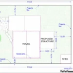
When I prepare a permit-ready site plan for a residential building permit, my focus is compliance, not aesthetics. Building departments review site plans to verify zoning compliance, structure placement, access, and adherence to municipal submission standards. If required information is missing or unclear, the application will be delayed or rejected. A properly prepared site plan is a technical document that demonstrates measurable compliance with setback requirements, lot coverage limits, and local permit guidelines.
1. Property Boundaries and Lot Dimensions
Every permit-ready site plan must clearly identify property boundaries. This is the foundation of zoning compliance.
Required details include:
- All property lines clearly drawn
- Lot dimensions labeled along each boundary
- Corner points identified where applicable
- Adjacent streets or public right-of-way labeled
Building departments use property boundaries to verify that the proposed structure does not encroach into restricted areas. If boundaries are inconsistent with official parcel records or missing measurements, the site plan approval process cannot move forward.

When I draft a residential building permit site plan, I ensure boundary information aligns with verified parcel data or an available survey. Accuracy at this stage prevents immediate correction notices.
2. Zoning Setback Requirements
Setbacks are among the most scrutinized elements during municipal review. A permit-ready site plan must show:
- Front setback distance
- Rear setback distance
- Side yard setbacks
- Required versus provided setback measurements
Simply drawing property lines is not sufficient. The distances from the proposed structure to each property boundary must be clearly dimensioned and labeled.
Zoning setback requirements vary by municipality and zoning classification. If a homeowner submits a site plan without explicitly demonstrating setback compliance, the building department will issue a revision request. I always calculate and label setbacks directly on the drawing to eliminate ambiguity.
3. Existing Structures and Improvements
A site plan for building permit approval must present a complete view of the property. That includes all existing structures.
Required elements typically include:
- Primary residence footprint
- Detached garages
- Accessory buildings
- Pools or patios
- Driveways
- Large decks or covered structures
Without a full property layout, zoning officials cannot evaluate total lot coverage or verify spacing between structures. Omitting existing improvements is one of the most common errors homeowners make when preparing their own drawings.
A permit-ready site plan must clearly distinguish between “existing” and “proposed” elements to prevent confusion during review.
4. Proposed Structure Placement and Dimensions
The core purpose of a residential permit site plan is to show what is being added or modified. The proposed improvement must be clearly identified.
The plan should include:
- Length and width of the new structure
- Total footprint dimensions
- Distance from proposed structure to property lines
- Distance to nearby existing structures
- Orientation relative to the lot
Whether the project involves a deck, garage, shed, pool, fence, or home addition, dimensioning must be precise. Building departments review these measurements to confirm lot coverage limits and spacing compliance.
I treat structure placement and dimensioning as non-negotiable technical requirements. Vague or incomplete measurements delay approval.
5. North Arrow and Drawing Scale
Professional formatting is mandatory for permit submission. Every permit-ready site plan must include:

- Clearly stated drawing scale (for example, 1” = 20’)
- Visible north arrow
- Proportional layout
The drawing scale allows reviewers to verify dimensions accurately. The north arrow establishes orientation relative to surrounding streets and adjacent properties.
Without scale or orientation, the plan is considered incomplete. Even if all other measurements are present, formatting deficiencies can lead to rejection.
6. Driveway Location and Access Points
Municipal review does not focus only on structures. Access and circulation matter as well.
A complete residential site plan must show:
- Driveway location
- Connection to public street
- Curb cut location, if applicable
- Parking area placement when relevant
In some jurisdictions, access changes trigger additional review. Failing to show driveway location can delay approval, especially when adding garages or expanding paved areas.
I ensure driveway placement is clearly labeled and consistent with the existing layout of the property.
7. Easements and Restricted Areas
Easements affect where construction can legally occur. A permit-ready site plan must identify:
- Utility easements
- Drainage easements
- Access easements
- Any restricted zones recorded on parcel data
Building departments must confirm that proposed improvements do not encroach into easement areas. If easements are omitted from the drawing, the plan may be returned for revision.
Homeowners often overlook this requirement because easements are not always physically visible. However, they are legally binding and must be represented when relevant.
8. Lot Coverage Calculations (When Required)
Some municipalities enforce maximum lot coverage limits. In these cases, the site plan may need to show:
- Total lot size
- Square footage of existing structures
- Square footage of proposed improvements
- Percentage of lot coverage
If the addition increases coverage beyond zoning limits, the project may require variance approval. Including lot coverage information upfront demonstrates awareness of zoning compliance and strengthens the permit submission.
9. Title Block and Permit Identification Information
Administrative details are often overlooked but required.
A professional residential permit site plan should include:
- Property address
- Owner name (if required)
- Drawing date
- Project description
- Revision notes, if applicable
Some municipalities also require permit application numbers to appear on the drawing. Missing administrative information can delay processing even if technical details are correct.
10. Compliance with Local Submission Guidelines
Finally, the entire site plan must align with local permit submission guidelines. This may include:
- Required PDF format
- Page size specifications
- Required labeling standards
- Digital upload compatibility
Every building department has specific formatting expectations. I always review municipal submission standards before finalizing a drawing to ensure the document meets local requirements.
How Building Departments Evaluate a Site Plan
During municipal building review, officials typically assess:
- Zoning compliance
- Setback accuracy
- Lot coverage limitations
- Structural spacing
- Encroachments into easements
- Formatting and clarity
If required information is missing or unclear, the plan will not proceed to structural review. The site plan approval process begins with zoning verification.
Conclusion
A permit-ready site plan must present complete, accurate, and clearly labeled information that allows building departments to verify zoning compliance without ambiguity. Missing boundaries, setbacks, structure dimensions, or formatting standards will delay approval. When every required technical element is included and professionally organized, the site plan approval process becomes significantly smoother and more predictable.
Why Choose Us
We prepare permit-ready site plans that align with municipal requirements and zoning standards across the United States.
- Accurate property boundaries based on verified parcel data
- Clearly labeled zoning setbacks and structure dimensions
- Professional formatting with scale, north arrow, and title block
- 24-hour turnaround for most residential projects
- Revision support to address building department comments
Frequently Asked Questions
1. What is the most important element on a permit-ready site plan?
Property boundaries and clearly labeled setback distances are typically the first items reviewed by building departments.
2. Do I need to show existing structures on my site plan?
Yes, all existing improvements must be shown so zoning officials can evaluate lot coverage and spacing compliance.
3. Are easements required to appear on a residential site plan?
If recorded easements affect the property, they must be clearly identified to prevent encroachment violations.
4. Does every city require lot coverage calculations?
Not every municipality requires them, but many enforce maximum lot coverage limits for residential zoning districts.
5. Can incorrect formatting cause permit delays?
Yes, failure to follow local submission guidelines, including scale and labeling standards, can result in correction notices.