If you’re planning to build a deck, garage, shed, pool, or an ADU (Accessory Dwelling Unit), understanding your site plan is crucial. A site plan shows the layout of your property and helps ensure your project meets city regulations, zoning rules, and permit requirements.
At Site Plans Online USA, we deliver fast, accurate, and permit-ready site plans online for homeowners across all 50 U.S. states, usually within 24–48 hours. These USA site plans are commonly accepted for residential permits and help homeowners avoid costly delays. In this guide, we’ll walk you through how to read a site plan, what the key components are, and how it can simplify your permitting process.
What Is a Site Plan?
A site plan is a detailed drawing of your property showing existing structures, proposed construction, boundaries, utilities, easements, and other site features. A properly prepared site plan is often required as part of the site plan for permit approval process by local city or county building departments.
Think of it as a map for your project, showing the “big picture” of how your property is organized. Cities, counties, and HOAs often require site plans for:
- Permit approval for new construction or renovations
- Ensuring setbacks and zoning rules are followed
- Safety checks for utilities, driveways, and drainage
Without a proper site plan, your permit application may face delays or rejection. While some projects require a certified site plan survey, most residential permits can be approved using professionally drafted site plans online.
For fast, professional, and accurate site plans, check our Drafting Services page.
Key Components of a Site Plan
When reading a site plan, pay attention to the following elements:
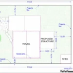
1. Property Lines and Boundaries
- Shown as solid or dashed lines
- Indicates your lot’s exact size and shape
- Includes measurements for front, back, and side setbacks
2. Existing Structures
- Your home, garage, shed, or pool already on the property
- Usually labeled and drawn to scale
- Helps ensure new additions don’t overlap or violate setbacks
3. Proposed Structures
- New decks, ADUs, driveways, or pools
- Typically shown in a different color or dashed outline
- Includes dimensions, location, and distance from property lines
4. Setbacks
- Minimum distance required by zoning laws from property lines, roads, or easements
- Crucial to ensure permit approval
- Often marked with measurements along the edges of the plan
5. Utilities and Easements
- Locations of water lines, sewer, gas, electrical, and drainage systems
- Easements are areas where construction may be restricted
- Helps prevent conflicts with city infrastructure
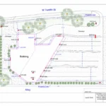
6. Driveways, Walkways, and Access Points
- Shows how vehicles and pedestrians enter and exit the property
- Includes dimensions for parking spaces, garages, and pathways
7. Topographical Features
- Hills, slopes, trees, and other natural features
- May include elevation markers for grading, drainage, or landscaping
8. Scale and Legend
- Scale indicates the ratio of drawing size to actual size
- The legend explains symbols, lines, and shading used in the plan
- Essential for accurate measurement and interpretation
Step-by-Step Guide: How to Read Your Site Plan
Follow these steps to read your site plan like a pro:
Step 1: Check the Scale
- Look for the scale, e.g., 1 inch = 10 feet
- Helps you measure distances accurately
Step 2: Identify Property Lines
- Find your lot boundaries and dimensions
- Note any irregular shapes or easements
Step 3: Locate Existing Structures
- Identify your home, driveway, garage, and other structures
- Compare their placement with city zoning requirements
Step 4: Review Proposed Additions
- Look for any new structures, decks, sheds, or pools
- Check measurements against setbacks and zoning rules
Step 5: Examine Utilities and Easements
- Make sure proposed construction does not interfere with water, sewer, or electrical lines
- Note any easements where construction may be restricted
Step 6: Understand Labels and Symbols
- Read the legend carefully
- Symbols may indicate trees, grading lines, or utility poles
Step 7: Confirm Orientation
- Identify north, south, east, west on the plan
- Ensures proper placement relative to your property and streets
Step 8: Double-Check Measurements
- Verify distances from property lines, structures, and easements
- Ensure all dimensions comply with local codes and permit requirements
Why Accurate Site Plans Matter
Accurate site plans save time, money, and stress:
- Faster Permit Approvals: Cities prefer clear, detailed plans
- Avoid Costly Mistakes: Prevent placement errors that could violate setbacks or easements
- Better Project Planning: Know exactly where your additions will fit
- Legal Compliance: Avoid fines or forced removals from improper construction
At Site Plans Online USA, we craft permit-ready site plans online using GIS-precision data, accurate measurements, and local zoning compliance standards.
Tips for Homeowners Reading a Site Plan
- Use a Ruler or Scale Tool – Measure distances accurately
- Ask Questions – Your city planning office can clarify zoning rules
- Look for Updates – Ensure the plan reflects current property conditions
- Check for Easements – Don’t build over utility or drainage easements
- Consult Experts – Professional drafting helps avoid mistakes and revisions
Learn more about professional drafting on our About Us and Drafting Services pages.
Common Symbols on Site Plans
| Symbol | Meaning |
|---|---|
| Solid line | Property boundary |
| Dashed line | Proposed structure or setback |
| Circle with X | Tree or landscaping feature |
| Square/rectangle | Building or garage |
| Lines with arrows | Driveway or pathway access |
| Parallel lines | Utilities or easements |
Understanding these symbols makes it easy to visualize your project before construction begins.
Frequently Asked Questions (FAQs) – Site Plans for Homeowners
1. What is a site plan and why do I need one?
A site plan is a detailed drawing of your property showing existing and proposed structures, setbacks, utilities, driveways, and easements. Cities require it as part of the site plan for permit process to ensure zoning, safety, and local code requirements are met.
2. Can I create my own site plan?
While homeowners can attempt simple sketches, most cities require professionally drafted, to-scale plans. Incorrect plans can lead to permit delays or rejection. Our affordable site plan services deliver accurate plans ready for approval.
3. How long does it take to get a site plan?
We deliver USA site plans digitally within 24–48 hours in all 50 U.S. states, using GIS data and professional CAD drafting.
4. Do you need to visit my property to draft a site plan?
No. We use GIS, satellite imagery, and city parcel data to create precise, to-scale site plans online without visiting your property.
5. What types of projects require a site plan?
Site plans are required for most construction or renovation projects, including:
- Decks, garages, sheds, and ADUs
- Swimming pools or patios
- Residential additions or remodels
- Commercial offices, retail shops, or warehouses
- Subdivision development
6. What is included in a typical site plan?
A standard site plan includes:
- Property boundaries and dimensions
- Existing and proposed structures
- Setbacks and zoning compliance
- Driveways, walkways, and parking
- Utilities and easements
- Topographical features and elevation (if needed)
7. Are your site plans approved by city permitting offices?
Yes. All our site plans online are drafted to meet local city and county codes, ensuring they are permit-ready for residential, commercial, or HOA submissions.
8. Can I get a site plan for unusual lot shapes or subdivisions?
Absolutely. We offer custom drafting for flag lots, corner parcels, subdivisions, or unique zoning requirements. Our plans are accurate and tailored to your property type.
9. How much does a site plan cost?
Our plans start at $99, making them one of the most affordable site plan services available for homeowners.
10. How do I get started with Site Plans Online USA?
Simply contact us or email drafting@siteplans.online with your project details. We provide a fast, no-obligation quote and deliver your site plan for permit approval within 24–48 hours.
Get Permit-Ready Site Plans Fast
Whether you’re in California, Texas, New York, or anywhere else in the U.S., we deliver accurate, to-scale, permit-ready site plans online in under 48 hours.
Our team of expert drafters ensures:
- Fast digital delivery — no site visit required
- Custom drafting for unique lot shapes or city requirements
- Floor plans and elevation drawings for complete permit packages
- Affordable flat-rate pricing starting at $99
Contact us today at drafting@siteplans.online to get your project moving.
Conclusion
Reading a site plan may seem overwhelming at first, but understanding boundaries, structures, setbacks, and utilities is essential for a successful construction project. With accurate, professional USA site plans from Site Plans Online USA, homeowners can save time, avoid mistakes, and get permits approved quickly.
Start your project with confidence and make your permitting process stress-free—get your site plan for permit approval delivered fast, accurate, and ready for submission.
See Related Guide:
How to Get a Site Plan for a Permit in the USA (2026Guide)