When applying for a building permit, one of the most commonly requested documents is a site plan. Many homeowners and contractors know they need one but are often unsure what a site plan shows, why the building department requires it, and how it differs from other drawings.
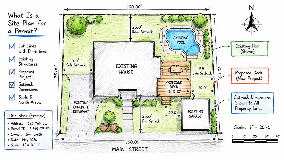
A site plan for a permit is a scaled, overhead drawing of a property that shows existing conditions, property boundaries, structures, and the location of a proposed project. Building departments use this drawing to verify that the project follows local zoning regulations, including setbacks, lot coverage limits, and placement requirements.
Simply put, a site plan answers one important question:
Can this project legally fit on this property according to local permit requirements?
At Site Plans Online USA, Engineer Wasim helps homeowners, contractors, and businesses prepare professional permit-ready site plans for residential and commercial projects throughout the United States.
Why Do Building Departments Require a Site Plan?
Before approving a permit, city and county reviewers need to understand how a proposed project affects the entire property. A construction drawing may show how something is built, but a site plan shows where it will be located.
A permit reviewer uses a site plan to verify:
- Property boundaries
- Building setbacks
- Existing structures
- Proposed improvements
- Lot coverage requirements
- Easements and access areas
- Compliance with local zoning rules
For example, if a homeowner wants to install a pool, fence, deck, ADU, or home addition, the permit office needs to confirm that the project is placed correctly on the lot.
A missing or incomplete site plan can result in:
- Permit correction notices
- Additional document requests
- Delayed approvals
- Revisions before submission
To understand specific drawing requirements, review our guide on site plan requirements for building permits.
What Does a Permit Site Plan Include?
A professional permit site plan contains important details that allow a building department to review the project accurately.
While requirements vary by location, most permit site plans include the following:
Property Boundaries and Lot Information
A site plan identifies the property being developed by showing:
- Property lines
- Lot dimensions
- Property address
- Parcel information
- Legal description when required
Accurate property information helps determine where construction can legally occur.
Existing Structures and Site Features
The drawing should show existing conditions on the property, including:
- Main building
- Garage
- Driveway
- Pool
- Fence
- Patio
- Deck
- Shed
- Other structures
Showing existing features allows reviewers to understand how the proposed project fits into the current property layout.
You can view examples of permit drawings in our guide about site plan examples for permits.
Proposed Project Location
The site plan must clearly show where the new construction or improvement will be placed.
Common examples include:
- Swimming pools
- Fence installations
- ADUs
- Home additions
- Garages
- Decks
- Commercial improvements
The proposed work should include accurate measurements so reviewers can verify compliance.
Setback Measurements
Setbacks are one of the most important parts of a permit site plan.
A setback is the required distance between a structure and property boundaries.
A site plan may need to show distances from:
- Front property line
- Rear property line
- Side property lines
- Existing structures
- Easements
Incorrect setback information is one of the most common reasons permit drawings receive corrections.
Scale, Dimensions, and Orientation
A permit site plan must accurately represent the property.
Important elements include:
- Drawing scale
- Dimension labels
- Structure sizes
- North arrow
- Site orientation
These details help reviewers understand the relationship between the property, existing improvements, and proposed construction.
Site Plan vs Survey vs Floor Plan
Many property owners confuse these documents because they are all used during construction projects. However, each serves a different purpose.
Site Plan
A site plan shows the property layout from above.
It focuses on:
- Property boundaries
- Outdoor improvements
- Building location
- Setbacks
- Site conditions
Floor Plan
A floor plan shows the interior arrangement of a building.
It includes:
- Rooms
- Walls
- Doors
- Windows
- Interior dimensions
Property Survey
A survey is generally prepared by a licensed land surveyor and establishes legal property boundaries.
A site plan may use survey information, but they are different documents.
Learn more about the differences in our guide:
Site Plan vs Survey vs Plot Plan
When Do You Need a Site Plan for a Permit?
Site plans are commonly required for exterior construction and property improvements.
Common projects include:
Residential Projects
- Pool permits
- Fence permits
- Shed permits
- Deck construction
- Patio projects
- Home additions
- Garage additions
- ADU construction
- Driveway expansion
Commercial Projects
Commercial site plans may include:
- Building placement
- Parking areas
- Access points
- Landscaping
- Site improvements
For commercial projects, requirements are usually more detailed because they involve larger developments and additional zoning considerations.
What Makes a Site Plan Permit-Ready?
Not every property drawing will be accepted by a building department. A permit-ready site plan should contain enough accurate information for the reviewer to evaluate the project.
A professional permit-ready site plan usually includes:
- Accurate property boundaries
- Existing structures
- Proposed improvements
- Setback dimensions
- Correct scale
- North arrow
- Title information
- Required calculations
- Project details
Requirements can vary by city and county, so the final drawing should match the standards of the reviewing authority.
Common Reasons Site Plans Get Rejected
Many permit delays happen because the submitted drawing does not contain enough information.
Common issues include:
Missing Measurements
Permit reviewers need accurate dimensions to confirm compliance.
Incorrect Setbacks
The proposed structure may appear too close to property boundaries.
Missing Existing Features
All important structures should be shown.
Incorrect Scale
A drawing that cannot accurately represent distances may be rejected.
Missing Required Information
Some jurisdictions require additional details depending on the project type.
You can learn more about common mistakes in our guide:
Top Reasons Site Plans Get Rejected
How Can You Get a Site Plan for a Permit?
Today, many homeowners and contractors use online drafting services to prepare permit site plans.
The typical process includes:
- Submit your project details
- Provide property information
- Share available documents or photos
- Drafting team prepares the site plan
- Review and revisions
- Receive the final permit-ready drawing
Site Plans Online USA provides online site plan preparation services for residential and commercial projects across the United States.
You can start your project through our permit site plan service.
How Much Does a Site Plan for a Permit Cost?
The cost of a site plan depends on:
- Project type
- Property complexity
- Location
- Required details
- Additional documentation
A simple residential project usually requires less work than a complex commercial development.
Use our Site Plans Cost Calculator to estimate your project requirements.
Get Your Permit-Ready Site Plan Today
A properly prepared site plan can help reduce permit delays and make the approval process smoother.
Whether you need a residential site plan, commercial site plan, ADU drawing, pool permit plan, fence permit plan, or another property drawing, Site Plans Online USA can help prepare professional documents for your project.
Request your site plan quote today and move your project forward with confidence.
Frequently Asked Questions
What is a site plan for a permit?
A site plan for a permit is a scaled drawing showing property boundaries, existing structures, proposed improvements, setbacks, and other details required by building departments to review zoning and permit compliance.
Is a site plan required for every building permit?
No. Requirements depend on the project type and local regulations. Many exterior projects such as pools, fences, additions, ADUs, decks, and commercial improvements commonly require a permit site plan.
What information should a permit site plan include?
A permit site plan usually includes property lines, structures, proposed construction, dimensions, setbacks, scale, north arrow, and other details required by the reviewing authority.
Can I create my own site plan for a permit?
Some jurisdictions allow owner-prepared drawings, while others require professionally prepared plans. Requirements depend on the project complexity and the rules of the local permit department.
What is the difference between a site plan and a survey?
A survey establishes legal property boundaries, while a site plan shows existing conditions and proposed improvements for permit review. Some projects may require both documents depending on local requirements.
Do pool permits require a site plan?
Many jurisdictions require pool site plans showing pool placement, dimensions, equipment areas, setbacks, and existing property features before approving a swimming pool permit.
Do ADU projects require a site plan?
Many ADU permits require site plans showing the existing home, proposed ADU location, setbacks, parking requirements, and other property information required by local authorities.
How much does a permit site plan cost?
The cost depends on project type, location, property complexity, and required details. Residential projects are usually less complex than commercial projects requiring additional documentation.
How long does it take to prepare a site plan?
The timeline depends on project complexity and available information. Projects with complete property details can usually be completed faster than projects requiring additional research or revisions.
Can Site Plans Online USA prepare site plans nationwide?
Yes. Site Plans Online USA provides online site plan drafting services for residential and commercial permit projects across many locations in the United States.
For what causes rejections: Why Site Plans Get Rejected
Is a Site Plan the Same as a Plot Plan?
Yes — in almost all US building permit contexts, a site plan and a plot plan are the same document. Different building departments use different terminology. Some say “submit a site plan.” Others say “provide a plot plan.” Both mean the same thing: a scaled overhead property drawing showing your project location.
- Site Plan for a Permit — Main Guide
- Site Plan for Building Permit
- Site Plan Example for a Permit
- How to Create a Site Plan for a Building Permit
- Site Plan vs Survey vs Plot Plan
- What Is a Site Plan
- Site Plan Drawing Requirements
Take the Next Step With Confidence
Avoid unnecessary delays and prepare for your permit application with greater confidence. Use our free tools to review your project and understand the next steps before moving forward.
ADU Feasibility Checker
Check whether your property may be suitable for an accessory dwelling unit.
Check ADU Feasibility 02Site Plan Checker
Review your drawing for common missing details and potential submission issues.
Review Your Site Plan 03Permit Requirements Checker
Identify the likely permit requirements for your location and project type.
Check Requirements 04Site Plan Cost Calculator
Get a quick site plan cost estimate based on your project requirements.
Calculate Your CostGet Your Permit Drawing Scope Reviewed
Send us the property address and project details. We’ll help identify the likely drawing scope and next step.

Engineer Wasim
Civil/Structural Engineer and founder behind Site Plans Online USA. His permit-drafting experience dates back to 2015, supporting residential, commercial, structural and site-development projects.
Learn More About Site Plans LLC →