
The most common question we receive before a homeowner places an order:
“Do I need to get a survey before you can draw my site plan?”
The answer is: usually no. And paying for one you don’t need costs $800 to $2,500 and adds 2 to 4 weeks to your project timeline.
This article tells you exactly when a survey is required, when it is not, what GIS parcel data can and cannot do, and how to determine which category your project falls into in under five minutes.
What Each Document Is and What It Does
A site plan and a boundary survey are two completely different documents prepared by two different professionals for two different purposes. Building departments need both to exist in the world but they do not always need both from you at the point of permit application.
What a site plan is?
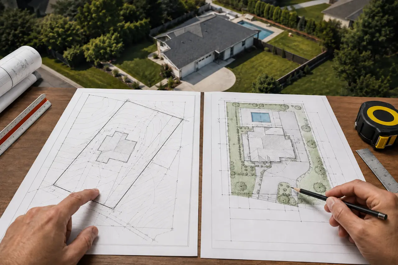
A site plan is a scaled, top-down drawing of your property showing your lot boundaries, all existing structures, and the exact location of your proposed project with every setback distance from the property lines labeled in feet.
<cite index=”8-1″>Required elements include lot dimensions, legal description, parcel ID, all existing structures with dimensions, proposed structure with dimensions, all setbacks labeled, north arrow, and site address.</cite>
Building departments use it to confirm that your proposed project meets local zoning rules before they issue the permit. That is its sole purpose. A site plan is a design and compliance document.
A licensed architect, civil engineer, or permit drafter prepares a site plan. In most US states, a site plan for a residential permit does not require a Professional Engineer stamp or a licensed surveyor’s signature it requires accurate dimensions and county-specific formatting.
What a boundary survey is?
<cite index=”11-1″>A boundary survey establishes the legal property lines and corners of a parcel using deed research, field measurements, and survey law. Only a licensed Professional Surveyor and Mapper (PSM) can legally establish boundary locations in Florida.</cite>
A boundary survey is a legal document. It is the authoritative statement of where your property begins and ends. It is signed and sealed by a licensed PSM. It is used to resolve property disputes, establish new lot lines, satisfy mortgage lenders, and in certain circumstances provide certified boundary data for permit applications.
<cite index=”12-1″>A site plan cannot replace a survey. Accurate site plans depend on survey data. For most Florida building permits, you need both.</cite>
That last sentence is technically true but practically misleading for most homeowners. Here is what it actually means: your property’s boundary data needs to exist and be accurate. For most residential lots, that boundary data already exists in the county GIS database and has existed since the property was originally platted and recorded. You do not need to commission a new survey to create data that already exists.
The Decision Tree
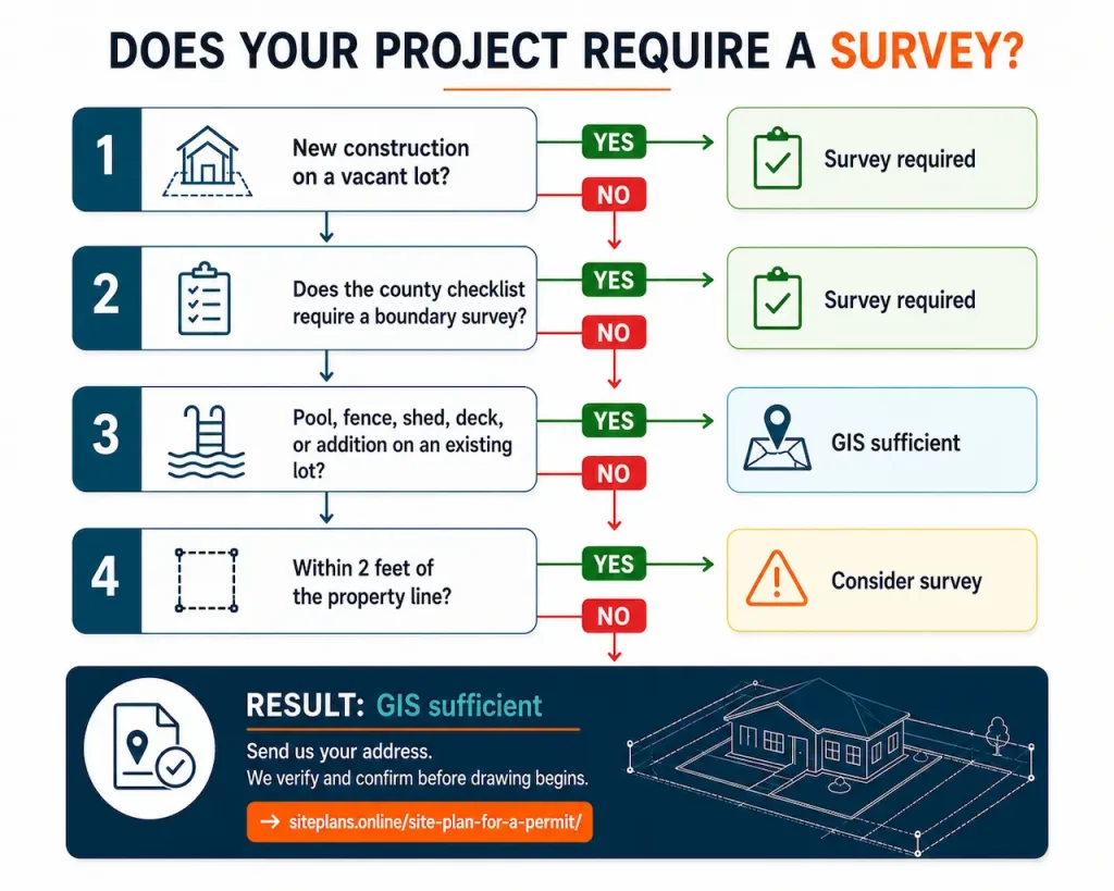
Before you call a surveyor or pay for anything, work through this:
┌─────────────────────────────────────────────────────────┐
│ DOES YOUR PROJECT REQUIRE A SURVEY? │
└─────────────────────────────────────────────────────────┘
│
▼
┌─────────────────────────────────────────────────────────┐
│ 1. Is this new construction on a vacant lot? │
│ (No existing house on the property) │
└─────────────────────────────────────────────────────────┘
YES → Survey almost certainly required. See Section 5.
NO → Continue ↓
│
▼
┌─────────────────────────────────────────────────────────┐
│ 2. Does your county’s permit checklist specifically │
│ say “current licensed boundary survey required”? │
└─────────────────────────────────────────────────────────┘
YES → Survey required. See Section 6 for when GIS may satisfy.
NO → Continue ↓
│
▼
┌─────────────────────────────────────────────────────────┐
│ 3. Is your project a pool, fence, shed, deck, │
│ or home addition on an existing developed lot? │
└─────────────────────────────────────────────────────────┘
YES → GIS parcel data almost certainly sufficient.
See Section 3.
NO → Continue ↓
│
▼
┌─────────────────────────────────────────────────────────┐
│ 4. Is the project within 2 feet of the property line? │
│ (Tight setback situation) │
└─────────────────────────────────────────────────────────┘
YES → Consider getting a survey. The margin is too thin
for GIS approximation. See Section 7.
NO → GIS parcel data is sufficient.
│
▼
┌─────────────────────────────────────────────────────────┐
│ RESULT: Send us your address. │
│ We pull the GIS parcel record, verify your lot │
│ dimensions, and confirm before drawing begins. │
│ → siteplans.online/site-plan-for-a-permit/ │
└─────────────────────────────────────────────────────────┘
What GIS Parcel Data Can Do
GIS — Geographic Information System is what county assessors and property appraiser offices use to maintain digital records of every parcel in their jurisdiction. When you search your address on a county property appraiser website and see your lot outlined on a map with dimensions, that is GIS parcel data.
Every county in every US state maintains this. It is publicly accessible, free, and updated regularly.
What GIS parcel data contains:
- Lot boundaries with dimensions in feet
- Total lot area in square feet and acres
- Parcel ID (APN) — the authoritative identifier
- Legal description
- Recorded easements (utility, drainage, access)
- Existing building footprints (from aerial imagery + permit records)
- Flood zone designation
- Zoning district
What GIS parcel data is accurate enough for:
For pool, fence, shed, deck, driveway expansion, home addition, ADU, and most residential permit site plans GIS parcel data is accurate to within a few feet. For a project that needs to clear a 5-foot setback requirement, being accurate to 2 to 3 feet is sufficient. The project will either clearly comply or clearly not comply.
<cite index=”6-1″>Orlando’s GIS portal at orlando.gov/maps allows you to find your property boundaries with accurate dimensions and total lot area the same data building departments use to verify zoning compliance.</cite>
We pull GIS parcel data for every order. Before drawing a single line, we have your lot boundaries, existing footprints, parcel ID, legal description, and flood zone status from the official county record. That data — combined with satellite imagery is what we draw from.
The GIS limitation to know:
GIS parcel data is derived from recorded plat documents and assessor records. It is accurate for the legal boundaries of most platted residential lots. It is not as precise as a fresh field survey a licensed surveyor physically locates the monuments and measures to a higher tolerance.
For most residential permits, that additional precision is not required by the building department. For new construction, properties with disputed boundaries, or projects within inches of the setback line a survey is the right call.
What GIS Cannot Certify
There are things GIS parcel data cannot do, and being clear about them prevents expensive mistakes.
GIS cannot locate physical survey monuments. A licensed surveyor physically locates the iron pins, concrete monuments, or other markers that establish your property’s corners in the physical world. GIS shows where those corners are supposed to be based on recorded documents. They are usually the same place but not always.
GIS cannot resolve boundary disputes. If a neighbor disputes where your fence line sits, GIS data is not the answer. A licensed survey is. GIS shows the legal boundary; a survey establishes it in the physical world.
GIS cannot certify elevation data. For flood zone properties, an Elevation Certificate is required prepared by a licensed surveyor or engineer. GIS shows flood zone designation but does not produce elevation data.
GIS cannot produce an as-built survey. After construction, some counties require an as-built (or foundation) survey showing where the structure was actually built. This requires a licensed surveyor in the field.
GIS accuracy varies by county. <cite index=”7-1″>The full parcel legal description must match county property records exactly.</cite> In most urban Florida counties, GIS data is very accurate. In rural areas with older recorded plats, there can be discrepancies between GIS data and the physical lot.
The Five Survey Types and When Each Is Required
Not all surveys are the same document. Here is what each one is and when a permit application actually requires it.
Boundary Survey
The most common survey type. Establishes the legal property lines in the physical world. Signed and sealed by a licensed PSM.
When required for permits:
<cite index=”9-1″>New construction in Florida typically requires a boundary survey before the building permit. Building departments across the state require professional surveys at multiple stages to ensure your project meets setback requirements.</cite>
Required for new home construction. Sometimes required for large additions (over a certain square footage threshold). Usually not required for pool, fence, shed, or deck permits on existing developed lots.
Cost in Florida: <cite index=”10-1″>Published Florida government contracts for 2024–2026 put a two-person survey crew at $130–$281 per hour and a licensed surveyor at $136–$383 per hour.</cite> Total project cost for a standard residential lot boundary survey: typically $500 to $2,000 depending on lot size, terrain, and county.
Turnaround: <cite index=”11-1″>Boundary surveys in Florida typically take 5 to 14 business days.</cite>
Topographic Survey
Maps existing terrain, drainage patterns, trees, and utilities. Your civil engineer uses it for grading plans.
When required for permits:
<cite index=”9-1″>A topographic survey maps the existing terrain, drainage patterns, trees, and utilities. Most building departments require a site plan based on topographic survey data.</cite>
Required for new construction and commercial site development. Not required for pool, fence, or shed permits.
Elevation Certificate
Documents the finished floor elevation of a structure relative to the Base Flood Elevation (BFE). Required for flood insurance purposes and for permits on properties in FEMA Special Flood Hazard Areas.
When required for permits:
Any permitted work on a property in a FEMA flood zone (Zone A, AE, VE) typically requires an Elevation Certificate. This is separate from your site plan.
ALTA / Commercial Survey
The most comprehensive survey type. Used for commercial property transactions and development. Not relevant for residential permit applications.
As-Built / Foundation Survey
Documents where a structure was actually built — after construction. Required by some counties before Certificate of Occupancy is issued. Prepared by a licensed surveyor after the project is complete.
When required:
Some Florida counties require this for new construction. Not required upfront for the permit application.
Survey Requirements by Florida County
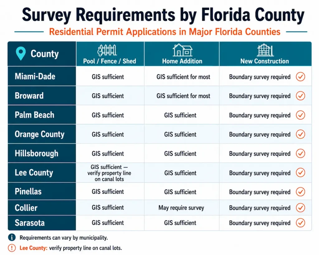
Florida has 67 counties. <cite index=”11-1″>While the Board of Professional Surveyors and Mappers sets statewide survey standards, individual counties have additional requirements for permits and construction. Requirements vary by municipality within each county.</cite>
Here is the practical picture for residential permit applications in major Florida counties:
| County | Pool / Fence / Shed | Home Addition | New Construction |
|—|—|—|—|
| Miami-Dade | GIS sufficient | GIS sufficient for most | Boundary survey required |
| Broward | GIS sufficient | GIS sufficient for most | Boundary survey required |
| Palm Beach | GIS sufficient | GIS sufficient | Boundary survey required |
| Orange County | GIS sufficient | GIS sufficient | Boundary survey required |
| Hillsborough | GIS sufficient | GIS sufficient | Boundary survey required |
| Lee County | GIS sufficient — verify property line on canal lots | GIS sufficient | Boundary survey required |
| Pinellas | GIS sufficient | GIS sufficient | Boundary survey required |
| Collier | GIS sufficient | May require survey | Boundary survey required |
| Sarasota | GIS sufficient | GIS sufficient | Boundary survey required |
The Lee County canal lot exception: On canal-front lots in Cape Coral and other Lee County waterfront areas, the recorded property line and the physical seawall face are two different points — typically 5 to 15 feet apart. We pull the recorded plat from the Lee County Property Appraiser database on every canal lot order to identify the exact property line. A fresh boundary survey is not required for pool permits in Cape Coral, but using GIS without understanding this distinction produces a wrong setback measurement.
<cite index=”11-1″>Miami-Dade typically requires surveys within 5 years for building permits.</cite> If you have a survey that is older than 5 years and are applying for a permit in Miami-Dade, check with the building department whether a new survey is required.
When a New Survey Is Worth Ordering
Even when a county doesn’t require it, there are situations where spending money on a survey before your permit application is the right call:
1. Your project is within 2 feet of the required setback
If your pool needs to clear a 5-foot setback and your GIS data suggests you have 6.5 feet — that is a 1.5-foot margin. GIS can be off by 2 to 3 feet. A licensed survey at $800 is cheaper than a correction notice, a resubmission, and a project delay.
2. You have a corner lot with unclear property lines
Corner lots often have sight triangles, easements, and frontage measurements that interact in complex ways. GIS usually captures this correctly, but if there is any ambiguity — particularly near the street — a survey confirms it definitively.
3. Your property has an older recorded plat
Properties in older neighborhoods platted before modern GIS systems were established sometimes have GIS data that doesn’t precisely match the physical monuments in the ground. If your lot was platted before 1980 and you haven’t had a recent survey, it is worth verifying.
4. You’re building new construction
<cite index=”9-1″>New construction in Florida typically requires a boundary survey before the building permit, construction staking before construction begins, a foundation survey after the foundation is poured, and an as-built survey or final survey before the certificate of occupancy.</cite>
5. You have an active dispute with a neighbor about the boundary
If a fence, wall, or structure near your property line is in question, a licensed survey resolves it. Building a new fence without knowing exactly where the legal boundary is can create a legal problem after construction is complete.
When You Have an Old Survey
You had a survey done 8 years ago when you bought the house. Can we use it?
Usually yes. Here is how to think about it:
Your old survey is almost always sufficient for:
- Pool, fence, shed, deck, and driveway permit site plans
- ADU site plans (the lot boundaries haven’t changed)
- Home addition site plans
If you have a recorded boundary survey — even an older one — send it to us. We incorporate your survey data into the site plan where it improves accuracy over GIS data. This is better than GIS data alone and does not require you to spend money on a new survey.
Situations where an older survey may not be sufficient:
- Miami-Dade for permits where the county specifically requires a current survey (within 5 years)
- New construction in most Florida counties
- Projects where improvements have been made to the property since the survey was conducted that are not reflected in the survey
If you have an old survey, send us a copy when you order. We will tell you whether it is sufficient or whether anything additional is needed for your specific county.
Aerial Imagery and What It Adds
Alongside GIS parcel data, we use high-resolution satellite and aerial imagery from multiple sources for every order.
Aerial imagery shows us:
- The actual footprint of every structure on your property
- The location of driveways, patios, pools, sheds
- Tree locations near the proposed project
- Setback situations that GIS dimensions alone don’t fully capture
Aerial imagery is current — updated at least annually for most urban Florida counties, more frequently in active development areas. Combined with GIS parcel boundaries and county property records, it gives us a complete picture of your property before drawing begins.
What aerial imagery cannot do: confirm exact boundary coordinates with legal precision. That is what a licensed survey does. For most residential permit applications, the combination of GIS parcel data and aerial imagery is sufficient.
Case Study: Survey Not Required, Problem Solved
A homeowner in Sarasota County called three permit services before contacting us. All three told her she needed a new survey before they could prepare her site plan. The project: a 10 × 14 ft shed in the rear yard.
We pulled the Sarasota County GIS parcel record. The lot was a standard recorded residential plat from 1988 — clean boundaries, clear legal description, no easements in the rear yard. The proposed shed needed to clear a 7.5-foot rear setback and a 7.5-foot side setback. GIS showed approximately 22 feet of clearance on each side. The margin was so comfortable that GIS precision was more than adequate.
We prepared the site plan from GIS and aerial imagery. No survey needed.
The homeowner saved $900 and 2 weeks. Her shed permit was approved on first submission.
The other three services weren’t wrong that surveys are sometimes required. They were wrong that they are always required. The answer depends on the project, the county, and the specific lot. We check before we draw.
Site Plan Types That Do and Don’t Require Surveys
Permits that almost never require a new survey:
- Fence permit site plan
- Shed / storage structure site plan
- Pool permit site plan (except new construction lots)
- Deck / porch / sunroom site plan
- Screen enclosure site plan
- Driveway expansion site plan
- ADU site plan (garage conversion or detached, existing lot)
- Home addition site plan (most counties)
- Metal building / pole barn (existing developed lot)
Permits where a survey is often required:
- New single-family home construction
- New commercial construction
- Site development plans (subdivision, commercial site)
- Projects in FEMA flood zones requiring Elevation Certificate
- Projects in Miami-Dade where the county requires a current survey
Certified vs Non-Certified: A Related Distinction
Separate from the survey question, Florida permit site plans fall into two categories:
Non-certified site plan: Prepared by a professional drafter, not signed by a licensed PE or surveyor. Sufficient for most residential permits — pool, fence, shed, deck, ADU site plan in most Florida counties.
Certified (PE-stamped) site plan: Signed, sealed, and dated by a licensed Professional Engineer. May be required for commercial or structural work depending on scope, discipline, jurisdiction, and project conditions.
Neither of these is a survey. A certified site plan with a PE stamp is still not the same as a boundary survey — it is a design document reviewed by an engineer, not a legal boundary document prepared by a surveyor.
→ What Is a Non-Certified Site Plan?
→ PE Stamp Services — From $299
What Happens If We Start Without a Survey and Need One
In the unlikely event that we begin drawing your site plan and discover that your specific county, your specific project, or your specific lot condition requires certified survey data — we tell you before delivering the plan.
We have never delivered a plan that we knew would fail intake because of a missing survey requirement. We verify your county’s submission checklist before drawing begins. If a survey is required for your project type in your county, we tell you at the start — not after you’ve paid and waited.
Forward the correction notice if a building department ever requests additional survey documentation on a plan we prepared. We address correction notices within 12 hours at no extra charge.
Frequently Asked Questions (FAQs)
Q: Can you prepare my site plan without a survey?
Yes for most residential projects. We use GIS parcel data and aerial imagery for pool, fence, shed, deck, ADU, and home addition permits in the vast majority of US counties. If your specific county requires certified boundary data for your project type, we tell you before drawing begins.
Q: I have a survey from 7 years ago. Can you use it?
Yes. Send us a copy when you order. We incorporate your existing survey data where it improves on GIS accuracy. For most Florida counties, a 7-year-old survey is sufficient for residential permit site plans. The exception is Miami-Dade, which may require a survey within 5 years.
Q: Does a pool permit in Florida require a survey?
No for most Florida counties. Pool permits require a site plan showing pool location, all four setbacks, F.S. 515.29 barrier compliance, equipment pad, and impervious surface calculation. This site plan is prepared from GIS parcel data. A new boundary survey is not required for pool permits on existing developed lots in most Florida counties.
Q: Is a GIS printout from the county website the same as a survey?
No. GIS data shows your property boundaries based on recorded documents. A licensed boundary survey physically locates your property corners in the field. They show the same information but to different standards of precision. For permit site plans, GIS data is sufficient for most residential projects. For legal boundary disputes, a licensed survey is required.
Q: Does new construction always require a survey in Florida?
<cite index=”9-1″>New construction in Florida typically requires a boundary survey before the building permit, construction staking before construction begins, a foundation survey after the foundation is poured, and an as-built survey or final survey before the certificate of occupancy.</cite> Yes — new construction on a vacant lot requires a boundary survey.
Q: What is the difference between a site plan, a plot plan, and a survey?
A site plan and a plot plan are the same document by different names — a scaled drawing showing your property and proposed project for permit submission. A survey is a different document prepared by a licensed surveyor establishing legal property boundaries. The permit application asks for the site plan. Some counties also ask for survey data as part of the application, depending on the project.
Q: How long does a boundary survey take in Florida?
<cite index=”11-1″>Boundary surveys in Florida typically take 5 to 14 business days.</cite> This is why determining early whether you actually need one matters — adding 2 weeks to your project timeline for a survey you didn’t need is a preventable delay.
Q: Can you incorporate my survey into the site plan?
Yes. If you have an existing survey, send it with your order. We incorporate the survey boundary data into the site plan for greater accuracy. This is better than GIS data alone and does not require an additional survey.
What to Do Right Now
If you have an existing survey:
→ Send your address and attach your survey — we confirm what’s needed within 2 hours
If you don’t have a survey:
If you’re not sure what you need:
→ Use the Permit Requirements Checker — enter your county and project type
→ Use the Site Plan Checker — verify what your county requires
→ Calculate your site plan cost
The answer to “do I need a survey” is almost always no for pool, fence, shed, deck, and ADU permits on existing developed lots. The answer is almost always yes for new construction. Every other situation is a county-specific question we answer before we start drawing.