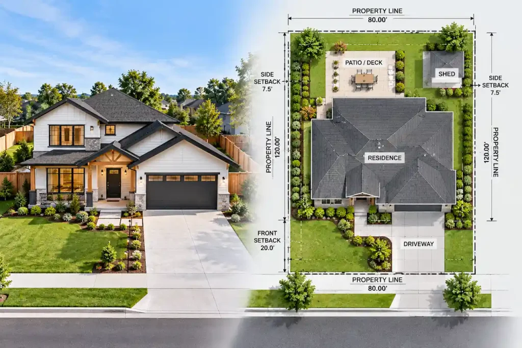

You need a site plan for a permit, but you do not have a recent property survey. Your county GIS website shows the parcel, property lines, aerial imagery, dimensions, and sometimes even buildings.
Can you simply use that GIS instead of a survey? Sometimes GIS and county parcel records can provide useful source information for preparing a permit site plan. But they are not automatically a substitute for a professional boundary survey. The key question is what your permit office requires.
If the city or county accepts a non-certified site plan based on available property records, GIS data may help establish the general parcel layout and provide information needed for drafting. If the permit authority specifically requires a current survey, certified boundary information, or a plan prepared by a licensed surveyor, county GIS records generally cannot satisfy that requirement by themselves.
Understanding that difference before preparing your permit documents can prevent corrections, redesigns, and unnecessary expense.
What Is a County GIS Parcel Map?
GIS stands for Geographic Information System. Cities, counties, property appraisers, assessors, and other government agencies commonly use GIS systems to organize geographic information about land and infrastructure. When you search your property on a county GIS portal, you may see information such as the parcel outline, parcel identification number, property address, recorded acreage, nearby streets, aerial imagery, zoning information, flood information, and other public data.
Some systems also display dimensions, easements, utility layers, contours, building footprints, or links to recorded documents. That makes GIS extremely useful for researching a property. But useful property information and a professional boundary survey are not the same thing.
Why GIS Property Lines Are Not the Same as Surveyed Boundaries
A line displayed on an online parcel map can look extremely precise. You can zoom in until the boundary appears to run along a fence, driveway, wall, or corner of a building. That visual precision can be misleading. GIS parcel layers are created primarily for mapping, assessment, planning, recordkeeping, and other administrative purposes. Their displayed parcel boundaries may be compiled from deeds, plats, surveys, tax maps, imagery, and other records. The aerial image underneath the parcel layer may also have its own positional limitations.
As a result, the parcel line and aerial photograph may not align perfectly with the actual legal boundary on the ground. A boundary survey, by contrast, involves professional surveying work to establish or document property boundaries using applicable records, measurements, monuments, and professional standards. That is why a GIS parcel line should not automatically be treated as a surveyed property line.
Can You Use GIS Instead of a Survey for a Permit Site Plan?
Potentially but only when the permitting authority does not require a professional survey and the available information is suitable for the proposed work. Consider a relatively straightforward residential project where the permit office allows the owner to submit a non-certified plot or site plan. If reliable property records are available, GIS information may be one source used to understand the parcel and prepare the drawing.
The resulting drawing should still contain the information required by the permit office. Using GIS as a source does not mean submitting a screenshot from the county website and calling it a complete permit site plan. The distinction is important:
GIS can provide source information. A drafted site plan organizes the information needed for permit review. A professional survey establishes or documents boundaries through surveying practice.
Those are three different things.
When County Parcel Records May Be Useful
County parcel information is particularly useful during the early stages of a project. It can help identify the parcel, understand its general shape, locate recorded information, and provide context before a site plan is prepared. For some straightforward permit applications, public records combined with other reliable documents may provide sufficient information for a non-certified drawing if the jurisdiction allows that approach.
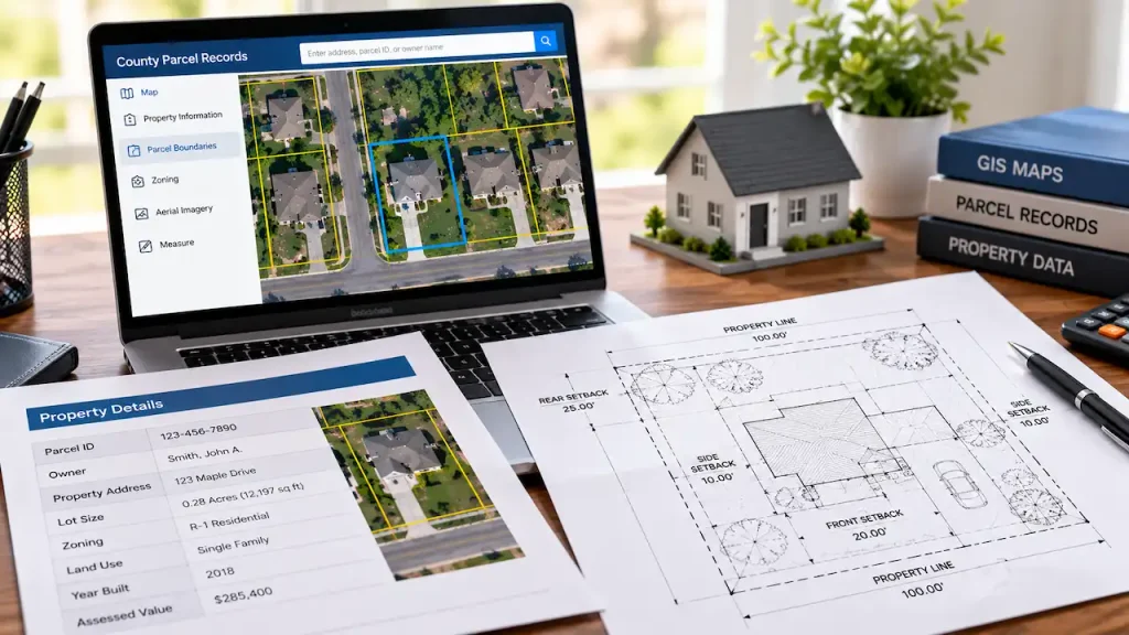
For example, imagine you are planning a shed well inside a large residential lot. The permit office allows a homeowner-prepared plot plan and does not request a current survey. You already have a recorded plat showing the lot dimensions, and county records provide additional parcel information.
Those records may be useful for preparing the required permit drawing. Now change the scenario, You want to build a garage only a few feet from what you believe is the rear property line, but your only boundary source is an online GIS map. The risk is substantially different. The closer the proposed construction is to a regulated boundary, the more important reliable boundary information becomes.
When You Should Not Rely on GIS Alone
There are several situations where treating GIS as an exact boundary source can create problems. The first is obvious: the permit office requires a survey. If the checklist specifically requests a boundary survey, certified survey, signed survey, or another document prepared by a licensed surveyor, substituting an online parcel map does not meet that requirement. Boundary-sensitive construction is another concern.
Suppose a proposed garage, shed, pool, addition, fence, or retaining wall is close to a property line. A small difference in the assumed boundary location could affect whether the project satisfies the required setback.
GIS should also be treated cautiously when parcel information conflicts with other records, property lines are irregular, the site contains uncertain easements, or neighboring improvements appear inconsistent with the mapped boundary. In these situations, guessing is usually a poor foundation for a permit submission.
What About County Parcel Dimensions?
Parcel dimensions displayed by a county can be valuable, but their source matters. A GIS portal may reproduce dimensions from a recorded plat or another underlying record. In other cases, the map may simply provide a visual representation of parcel geometry. Rather than assuming every number displayed online has survey-level authority, identify the underlying document whenever possible.
A recorded subdivision plat, for example, may contain legal lot dimensions and other recorded information that is more useful than measuring a line directly from an aerial map. The goal is to work from the strongest available source information appropriate for the project.
GIS vs. Recorded Plat vs. Survey
These documents are often confused because all three can show property information. A GIS parcel map is a digital mapping resource. It is excellent for research and general property context but should not automatically be treated as a legal boundary determination. A recorded plat is an official recorded document that may show lot boundaries, dimensions, easements, streets, rights-of-way, and other subdivision information.
A boundary survey is professional surveying work focused on establishing or documenting the property boundary and relevant site conditions according to the scope of the survey. One may provide information used alongside another, but they are not interchangeable simply because each contains lines representing a parcel.
Can an Old Survey Still Be Useful?
Yes, If you already have an older survey, do not assume it is useless simply because it was prepared years ago. It can provide valuable information about property boundaries and existing conditions at the time of the survey. The important question is whether anything relevant has changed and whether the permit office accepts the document for the current project.
For example, an old survey may not show a newer addition, pool, garage, shed, driveway, or other improvement. A permit site plan may therefore need to show updated existing conditions plus the newly proposed work. In other cases, the authority may specifically request a current survey. Keep the existing survey and provide it when discussing the drawing requirements. It may still be one of the most valuable property documents available.
Can Google Maps or Satellite Imagery Replace a Survey?
Aerial and satellite imagery can be useful for understanding visible site conditions, but an image of the property does not establish legal boundaries. The same caution applies to measuring distances using online map tools. Those measurements may help with preliminary planning, but they should not be represented as professionally surveyed boundary measurements.
Imagery can still be helpful when preparing a site plan because it may show the approximate location of buildings, driveways, pools, paved areas, and other visible improvements. It should simply be used for the purpose it is suited for.
What If the City Allows a Hand-Drawn Plot Plan?
Some permit authorities accept relatively simple owner-prepared plot plans for certain residential projects. If that is what the published requirements allow, a professionally surveyed drawing may not automatically be necessary. But “hand-drawn” does not mean the information can be guessed. The applicant may still need to show property boundaries, dimensions, existing buildings, proposed construction, and setback measurements accurately enough for review. The city may also require a particular scale or additional project-specific information. Always follow the actual checklist.
A simple drawing that satisfies the city’s requirements can be more useful than an elaborate drawing that omits the information the reviewer needs.
How Setbacks Make Boundary Accuracy Important
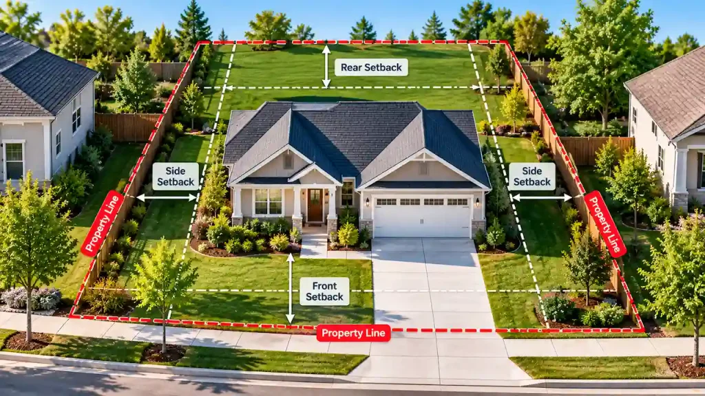
Setbacks are measured in relation to boundaries or other regulated features. That creates an important relationship between the accuracy of your property information and the reliability of the setback shown on the plan. Suppose zoning requires your proposed structure to remain a certain distance from the rear property line. If the assumed property line is wrong, the setback calculated from that line may also be wrong. This is particularly important when a proposed improvement is close to the minimum allowed setback.
A project located comfortably away from all boundaries may present a different level of risk than one designed to sit close to the zoning limit. The permit authority ultimately determines what boundary documentation it requires.
Easements Are Another Reason to Check the Records
Property lines are not the only invisible constraints that matter. A parcel may contain utility, drainage, access, conservation, or other easements that affect where improvements can be placed. Some GIS systems display easement-related layers, but not every recorded easement will necessarily appear accurately or at all on a public parcel viewer.
Recorded plats, deeds, title documents, surveys, and other property records may contain information that is not obvious from the aerial map. Before placing a permanent structure, review the available property documentation rather than assuming an empty area on the GIS image is automatically buildable.
What Information Can Be Used to Prepare a Site Plan Without a New Survey?
When a jurisdiction allows a non-certified site plan, the drawing may be developed from a combination of available property information. Useful source documents can include an existing survey, recorded subdivision plat, deed information, county parcel records, GIS data, previous approved plans, permit records, and measurements or project information supplied by the property owner. No single source should automatically be treated as more accurate than it actually is.
If the available records conflict or do not provide enough information to establish what the permit office requires, additional documentation may be necessary. That is preferable to presenting assumptions as verified conditions.
When Is a Professional Survey the Safer Choice?
A professional survey becomes particularly important when the permit authority requires one or when precise boundary information is critical to the project. That can occur when construction is close to a property line, boundary locations are disputed or uncertain, existing records conflict, or the proposed work interacts with easements or other boundary-sensitive conditions.
Certain projects and jurisdictions may also have specific survey requirements regardless of how straightforward the property appears. Ordering a survey should therefore be based on the project risk and permit requirements, not on the assumption that every permit needs one or that none do.
How to Check What Your Permit Office Accepts
Before ordering documents, find the permit requirements for your specific project type. Do not search only for “site plan requirements.” Look for the checklist for the actual work you are proposing, such as a garage, shed, pool, deck, addition, ADU, fence, or driveway.
Pay attention to wording such as:
Site plan, Plot plan, Boundary survey, Certified survey, Survey showing proposed improvements, Scaled drawing, Owner-prepared plan.
Those terms can reveal the expected level of documentation.
If the instructions remain unclear, ask whether a non-certified site plan prepared from existing property records is acceptable or whether a current professional survey is required. That single clarification can determine the correct approach.
Don’t Buy a Survey Before Checking But Don’t Avoid One When It Is Required
Homeowners often fall into one of two extremes. Some assume every permit requires a new survey and pay for one before checking the application requirements. Others try to avoid surveying entirely and rely on an approximate online parcel boundary even when precise boundary information is essential. Neither approach is ideal. Start with the permit requirements and the property documents you already have.
If the jurisdiction accepts a non-certified site plan and adequate records exist, preparing the permit drawing without commissioning a new survey may be possible.
If the authority requires surveyed information, or the available records cannot reliably support the proposed placement, obtain the appropriate professional survey.
Preparing a Permit Site Plan From Available Property Records
If your jurisdiction allows a non-certified plan, the next step is to gather the strongest available information. Start with your project address and parcel number. Then collect any existing survey, recorded plat, previous site plan, deed information, county parcel records, permit documents, and other relevant property records. Provide the dimensions and intended location of the proposed work. Also provide the city’s permit checklist or correction notice when available.
The purpose is not to disguise public mapping information as surveyed data. It is to use appropriate available records to prepare a clear permit drawing when that type of plan is accepted.
GIS Can Help But Know Its Limits
County GIS systems are valuable property-research tools. They can help identify parcels, locate records, understand general site conditions, and provide information that may support preparation of a non-certified permit site plan. But the existence of an official-looking parcel line on a government website does not make that line equivalent to a boundary established by a licensed surveyor.
So, can you use GIS instead of a survey? For some permit applications, you may be able to use GIS and other property records as source information when the jurisdiction accepts a non-certified site plan. But when the permit authority requires a survey or when reliable boundary determination is essential GIS should not be used as a substitute.
Site Plans Online can prepare permit site plans from appropriate available property information for projects where that approach fits the jurisdiction’s requirements. If a professional survey or other licensed service is required, that should be identified before the drawing is relied on for permit submission.
Frequently Asked Questions
Are county GIS property lines accurate?
County GIS parcel lines can be useful for general property research, but they should not automatically be treated as surveyed legal boundaries. Their positional accuracy and source data vary.
Can I use a county parcel map for a building permit?
Possibly as source information, depending on the project and jurisdiction. A parcel-map screenshot alone may not contain everything required for a permit site plan, and it does not replace a survey when one is specifically required.
Can GIS replace a boundary survey?
GIS does not perform the same function as a professional boundary survey. If surveyed boundaries or a licensed surveyor’s certification are required, GIS cannot substitute for that professional work.
Do I need a survey to get a site plan?
Not always. Some jurisdictions accept non-certified site plans based on appropriate existing records for certain projects. Other projects require a current or certified survey. Check the local permit requirements.
Can I use an old survey for a permit?
An existing survey may still provide useful boundary information, but acceptance depends on the jurisdiction and whether the property conditions shown remain relevant. New improvements may need to be added to the permit drawing.
Can Google Maps be used for a permit site plan?
Aerial imagery can help identify visible site features, but it should not be treated as a professional boundary survey. Whether imagery can be used as supporting source information depends on the required plan and jurisdiction.
What if my GIS map and old survey do not match?
Do not simply choose the boundary that works best for the project. Conflicting property information is a reason to investigate the source records and may indicate that professional surveying is appropriate.
How do I know whether my city requires a survey?
Check the permit checklist for your specific project and look for requirements such as “boundary survey,” “certified survey,” or a plan prepared by a licensed surveyor. If the language is unclear, confirm the requirement with the permitting authority before preparing the site plan.
Get Your Permit Drawing Scope Reviewed
Send us the property address and project details. We’ll help identify the likely drawing scope and next step.

Engineer Wasim
Civil/Structural Engineer and founder behind Site Plans Online USA. His permit-drafting experience dates back to 2015, supporting residential, commercial, structural and site-development projects.
Learn More About Site Plans LLC →