A residential permit site plan shows how your existing property and proposed project fit together on the lot. It typically identifies property boundaries, existing structures, proposed work, dimensions, setbacks, access, and other site conditions needed for permit review. But there is no single site-plan checklist that applies to every residential project in the United States.
A site plan for a small shed can be much simpler than one for a home addition, detached garage, ADU, pool, or project involving grading and drainage. The city or county reviewing the permit ultimately determines what must be shown.
Understanding the common requirements before preparing the drawing, however, can help you gather the right information and avoid obvious omissions.
What Is a Residential Permit Site Plan?
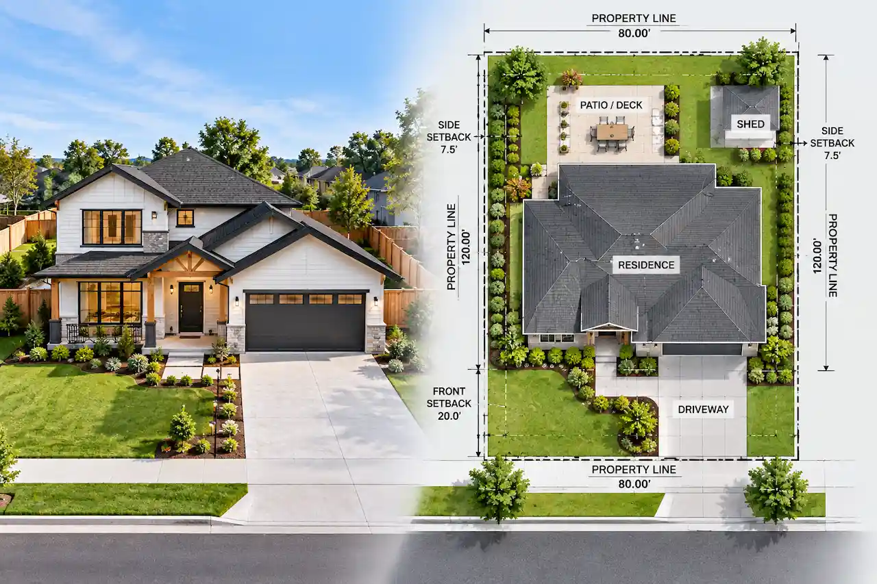
A residential site plan is an overhead drawing of a property prepared to communicate existing and proposed site conditions. Think of looking straight down at the lot from above. The plan shows where the house sits, where the property boundaries are, and where the proposed project will be located.
Depending on the permit, it may also show driveways, accessory structures, easements, setbacks, utilities, drainage features, lot coverage, and other relevant improvements. The purpose is not simply to create an attractive property drawing.
The site plan gives permit and zoning reviewers information they need to evaluate whether the proposed project fits the property and applicable requirements.
What Should a Residential Site Plan Include?
The exact content varies by jurisdiction and project, but several elements commonly appear on residential permit site plans. These can include:
- Property boundaries
- Lot dimensions
- Existing house
- Existing accessory structures
- Proposed construction
- Dimensions of proposed work
- Setback distances
- Streets and alleys
- Driveways and access
- Known easements
- North arrow
- Drawing scale
- Relevant utilities
- Lot or building coverage when required
- Grading or drainage information when required
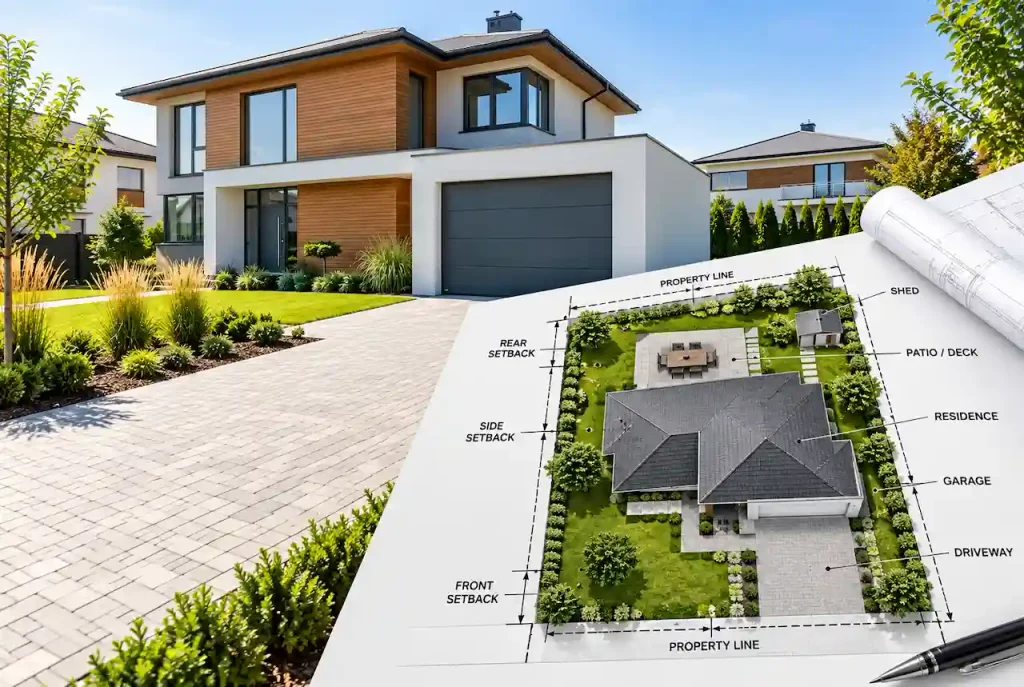
Not every project requires every item on this list. Likewise, some jurisdictions require information beyond it. The permit checklist for the specific project should always take priority.
1. Property Lines and Lot Dimensions
The property boundaries establish the framework for the entire site plan. They show the extent of the parcel and provide the reference from which many setback dimensions are measured. Where required, relevant lot dimensions should also be shown. The source of this information matters. Property boundaries may come from an existing survey, recorded plat, or other appropriate property records depending on the type of plan being prepared and what the jurisdiction accepts. County GIS maps can be useful for research, but approximate GIS lines should not automatically be represented as professionally surveyed boundaries.
If the permit office requires a current boundary survey, a drafted site plan cannot replace that professional requirement.
2. The Existing House
The primary residence should be clearly represented on the plan. Its footprint gives the reviewer context for the proposed project and helps establish how new construction relates to existing development. For an addition, attached garage, deck, or patio cover, the connection to the house can be especially important. The drawing should make it easy to distinguish the existing building from new work.
Depending on the project, dimensions or distances associated with the existing house may also be necessary.
3. Existing Accessory Structures and Improvements
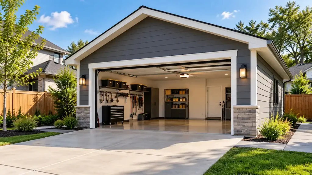
The house may not be the only existing feature that matters. A property can already contain a detached garage, shed, pool, deck, patio, driveway, retaining wall, fence, or other improvement. Relevant existing conditions should be represented where they affect the permit review.
This becomes particularly important when evaluating building separation, available yard area, lot coverage, access, or the relationship between the proposed project and existing improvements. Leaving existing structures off the plan can create an incomplete picture of the property.
4. The Proposed Project
The proposed work should be immediately identifiable. If you are building a garage, the plan should clearly label the proposed garage. If you are adding a pool, addition, shed, deck, patio cover, or driveway expansion, that improvement should be clearly distinguished from existing conditions. Relevant dimensions should also be included.
A reviewer should not have to guess whether a line represents an existing structure, something being demolished, or new construction. Clear labels and consistent linework make the project easier to understand.
5. Setback Dimensions
Setbacks are among the most important dimensions on many residential site plans. They indicate the distance between a structure and relevant property boundaries or other regulated features. Depending on the project, reviewers may need front, rear, side, or street-side setback dimensions. A proposed accessory structure may also need to maintain a required distance from another building. There is no universal setback that applies to every residential property.
The applicable requirement can depend on the zoning district, lot type, project, structure height, attached or detached status, and other local rules. The site plan should show the proposed dimensions. The jurisdiction determines whether those dimensions comply.
6. Streets, Alleys and Rights-of-Way
The plan should identify adjacent streets where relevant. Alleys can also be important, especially for garages, parking, and properties with rear access. Rights-of-way may affect where property improvements can be placed and where private property transitions to public infrastructure. Corner lots require particular attention because more than one side of the property can face a street. A yard that looks like a normal side yard may be regulated differently because of the adjacent street.
Accurately showing these relationships helps the reviewer understand the lot configuration.
7. Driveways and Vehicle Access
Driveways are particularly relevant for garages, carports, ADUs with parking, driveway expansions, and other projects involving vehicle access. The site plan may need to show the existing driveway and any proposed changes. If a new curb cut, driveway apron, or work within the public right-of-way is proposed, additional approvals may be necessary.
Driveways can also affect lot or impervious coverage calculations in jurisdictions that regulate paved surfaces. The exact information needed depends on the project.
8. Easements
An easement can affect where improvements are allowed even when the project complies with normal zoning setbacks. Residential properties may contain utility, drainage, access, or other easements. Some are visible on recorded plats or surveys. Others may require additional property-record research. If a known easement is relevant to the proposed construction, it should not be ignored. A shed, garage, pool, addition, retaining wall, or other permanent improvement proposed within an easement may require additional review or relocation.
The terms of the easement and requirements of the appropriate authority ultimately determine what is permitted.
9. North Arrow and Drawing Scale
A north arrow helps orient the property. The drawing scale allows dimensions and site relationships to be communicated consistently. Some permit offices specify acceptable scales or sheet sizes. Others provide example plot plans showing their preferred format. Follow the published submission requirements where they exist. A screenshot from an aerial map is not automatically a permit-ready site plan simply because it shows the property from above. The drawing needs to communicate the required information clearly.
10. Lot Coverage or Building Coverage
Some residential projects affect zoning calculations related to how much of the lot is developed or covered. Terminology varies, A jurisdiction may regulate building coverage, lot coverage, impervious coverage, or a related measurement. These terms should not be assumed to mean the same thing.
For example, a covered patio might count toward one calculation while an uncovered paved area may be treated differently under another. When the permit requires a coverage calculation, the plan may need to show the existing and proposed areas used in that calculation. A project can meet its setbacks and still have a coverage issue.
11. Utilities When Relevant
Not every residential site plan requires a complete utility layout. But utilities can become important when the proposed construction interacts with them. Relevant features might include water service, sewer, septic systems, gas, electrical service, utility poles, or other infrastructure. A detached garage, addition, pool, or ADU may introduce different utility considerations from a simple fence. Known utility conflicts should be addressed rather than ignored.
For more complex projects, separate utility or engineering drawings may be required.
12. Grading and Drainage Information
A simple residential site plan does not automatically include a complete engineered drainage design. However, grading and drainage can become important when a project changes site elevations or adds substantial roof and paved area. An addition, driveway expansion, retaining wall, pool, or new structure can affect how water moves across the property. Some jurisdictions may require elevations, drainage arrows, contours, swales, or other information. More complicated sites may require a separate grading and drainage plan. The scope should match the permit requirements and actual site conditions.
Existing vs. Proposed Conditions Must Be Clear
One of the simplest ways to improve a residential permit plan is to make the project scope obvious. A reviewer should be able to quickly understand what exists now, what will be removed, and what will be added.
For example, imagine a property with an existing house and shed where a detached garage is proposed. The house and shed should be identified as existing, while the garage should be clearly labeled as proposed.
If the shed will be removed before garage construction begins, the plan should also show that where relevant. Clear labeling helps prevent reviewers from having to interpret ambiguous linework or guess which elements are existing, proposed, or scheduled for removal.
What Is Not Automatically Included in a Site Plan?
A site plan should not be confused with a complete permit drawing set. For many building projects, additional documents may be required beyond the site plan itself.
These documents can include floor plans, elevations, sections, foundation plans, framing plans, structural details, energy documentation, electrical drawings, plumbing information, and other project-specific plans.
The site plan primarily answers where the project is located on the property. The rest of the permit set explains what is being built and how it will be constructed.
For some simple projects, the site plan may be the main drawing required. For larger or more complex projects, it is usually only one part of the full permit submission.
Residential Site Plan vs. Plot Plan
In residential permitting, the terms site plan and plot plan are sometimes used interchangeably. One city may ask for a plot plan for a shed, while another may request a site plan for essentially the same type of project.
The title of the drawing matters less than the information the permit office requires. If a permit checklist says “plot plan” and asks for property lines, structures, setbacks, driveways, easements, and dimensions, those are the requirements the drawing should satisfy.
For this reason, the scope of the drawing should be based on the permit checklist and project requirements rather than on the document name alone.
Residential Site Plan vs Property Survey
A residential site plan is not automatically the same as a property survey. A professional survey involves surveying services performed within the specific scope of that survey. A residential permit site plan may instead use appropriate existing property information to show the relationship between existing improvements, proposed work, and the overall property layout.
If the jurisdiction specifically requires a boundary survey, certified survey, or document prepared by a licensed surveyor, a non-certified site plan should not be presented as a substitute.
This distinction becomes especially important when proposed construction is close to a property boundary or when precise boundary verification is necessary for permit review.
Can You Prepare a Site Plan Without a New Survey?
In some cases, a new survey may not be required. If the jurisdiction accepts a non-certified site plan and reliable property information is already available, existing records may provide enough information to prepare the drawing.
An existing survey can be particularly useful, while recorded plats, previously approved plans, county records, and other appropriate property documents may also provide valuable source information.
The situation changes when the permit office specifically requires a current survey or when reliable boundary information cannot be established from existing documents. For that reason, it is best to review the permit requirements before deciding whether a new survey is necessary.
What Different Residential Projects May Need
The basic site-plan concept remains the same, but project type changes the details reviewers care about.
Garage or Carport
Garage or Carport site plans may require particular attention to setbacks, building separation, driveway access, easements, and lot coverage.
Home Addition
Home Addition / Remodel Plans changes the main building footprint, making setbacks, existing conditions, coverage, and connection to the house especially important.
Pool
Pool projects can introduce placement, access, equipment, barriers, utilities, drainage, and other site-specific requirements.
Shed
A shed site plan may be relatively straightforward, but setbacks, easements, dimensions, and accessory-structure rules still matter.
Deck or Patio Cover
Deck / Porch / Patio Cover Plans these projects may involve setbacks, structural connections, footings, lot coverage, and the relationship to the existing house.
Fence
Fence plans often focus on property boundaries, fence location, height, corner visibility, gates, and other zoning requirements.
Driveway
A driveway project can involve access, curb or apron work, right-of-way conditions, drainage, and changes to impervious area.
Each project should follow its own permit checklist.
When Does a Residential Site Plan Need a PE Stamp?
Not every residential site plan requires an engineer’s seal. However, a project may include other drawings or calculations that require professional engineering. Structural design, retaining walls, complex foundations, grading, drainage, or other technical conditions may trigger additional requirements depending on the project and jurisdiction.
Similarly, some work may require an architect, licensed surveyor, or another professional. A standard site plan should not be presented as a substitute when the authority requires licensed professional services.
Common Reasons Residential Site Plans Get Rejected or Corrected
A permit correction does not necessarily mean the entire project is wrong. In many cases, the reviewer simply does not have enough information to verify compliance with the applicable requirements.
A plan may be missing a setback dimension, the proposed structure may not be labeled clearly, or an existing garage or shed may be left off the drawing. The driveway may also be missing even when the project affects vehicle access.
Corrections can also result from missing easements, incomplete lot-coverage information, or inconsistent dimensions between different sheets in the permit package. Clear, complete, and coordinated drawings help reduce unnecessary questions and revisions during the review process.
What Should You Gather Before Ordering a Residential Site Plan?
Start with the permit requirements for your specific project, then gather the strongest property information you already have. An existing survey can be especially useful, but a recorded plat, previous site plan, property documents, or earlier approved permit drawings may also help.
You should also know the approximate dimensions and intended location of the proposed work. For an addition or attached project, provide the relevant building dimensions. For a garage or carport, include information about the proposed vehicle access. For a patio cover or deck, identify where the new structure will connect to the existing house.
If you have already received a correction notice, provide the complete notice rather than describing the issue from memory. This gives the drafter a much clearer understanding of what the reviewer is requesting and what changes may be needed.
Check the Permit Checklist Before the Drawing Is Finished
A common mistake is preparing what appears to be a complete site plan and only afterward checking the city’s requirements. A better approach is to reverse that process and review the permit requirements before the drawing is finalized.
Start by identifying the project type and reviewing jurisdiction. Then locate the applicable construction permit checklist, application instructions, or example drawings provided by the city or county.
Determine whether the jurisdiction requires a survey, specific drawing scale, lot-coverage calculation, drainage information, structural documents, or other project-specific details. The site plan can then be prepared around those requirements from the beginning.
This approach is much more efficient than repeatedly adding information after receiving permit corrections.
What Makes a Residential Site Plan Permit-Ready?
A permit-ready residential site plan is not simply one that looks professional. It must clearly communicate the information required for the specific permit review.
The property should be identifiable, and the existing and proposed conditions should be easy to distinguish. Relevant dimensions should be readable, and the proposed project should be shown clearly in relation to property boundaries, existing structures, and other important site features.
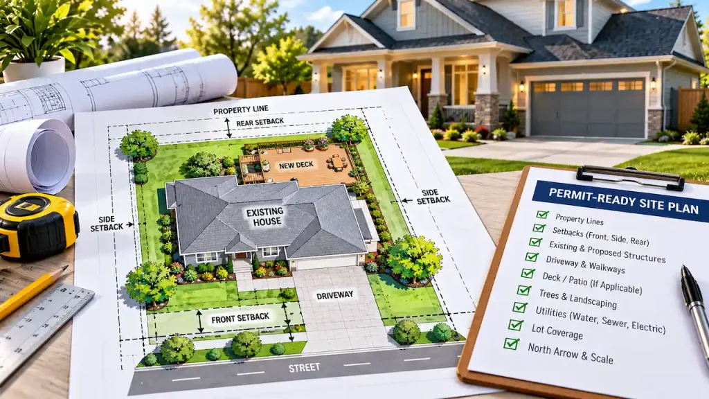
The site plan should also be consistent with the other documents in the permit package. Dimensions, building locations, and project details should not conflict from one drawing to another.
Most importantly, the plan should accurately represent its scope and should not claim to provide professional surveying, engineering, or another certification that falls outside the services actually performed.
Need a Residential Site Plan for a Permit?
Site Plans Online prepares residential site plans and permit drawing support for projects across the United States. Projects can include garages, carports, additions, decks, patio covers, pools, sheds, fences, driveways, ADUs, and other residential improvements. To get started, provide the property address, project type, proposed dimensions and location, any existing survey or property documents, and the local permit requirements when available.
If the permit office has already issued corrections, provide those comments as well. The appropriate drawing scope can then be based on the project and the information the reviewing jurisdiction actually requires.
Frequently Asked Questions
What is included in a residential site plan?
A residential site plan commonly includes property boundaries, the existing house, relevant existing improvements, proposed construction, dimensions, setbacks, streets, access, known easements, north arrow, and scale. Additional information may be required depending on the project.
Do I need a site plan for a building permit?
Many residential projects require a site or plot plan, particularly when the work changes the property’s exterior layout or building footprint. Requirements vary by project and jurisdiction.
Does a residential site plan show property lines?
Yes, a site plan can show property boundaries based on appropriate source information. However, displaying a boundary does not make the drawing a professional boundary survey.
Do I need a survey before getting a site plan?
Not always. Some jurisdictions accept non-certified site plans based on appropriate existing property information. Others require current or professionally surveyed boundaries.
Can I use a county GIS map as my site plan?
GIS can provide useful source information, but a parcel-map screenshot is not automatically a complete permit site plan or boundary survey. The drawing must satisfy the permit office’s actual requirements.
Does a site plan include structural drawings?
Usually not. The site plan primarily communicates the property’s layout and project location. Structural plans and calculations are separate documents when required.
How detailed does a residential site plan need to be?
The required detail depends on the project and jurisdiction. A shed may need a simpler drawing than an addition, garage, pool, or project involving grading and drainage.
What happens if my site plan is missing information?
The permit reviewer may issue correction comments asking for additional dimensions, property information, project details, or other required documentation. Addressing the applicable checklist before submission can reduce avoidable corrections.
Get Your Permit Drawing Scope Reviewed
Send us the property address and project details. We’ll help identify the likely drawing scope and next step.

Engineer Wasim
Civil/Structural Engineer and founder behind Site Plans Online USA. His permit-drafting experience dates back to 2015, supporting residential, commercial, structural and site-development projects.
Learn More About Site Plans LLC →